

Crews evacuated dozens of people from vulnerable locations in the northwestern Bahamas as Tropical Storm Nicole approached Wednesday and residents of Florida braced for the storm, which could strengthen to a rare November hurricane.
“We are forecasting it to become a hurricane as it nears the northwestern Bahamas, and remain a hurricane as it approaches the east coast of Florida,” Daniel Brown, a senior huricane specialist at the Miami-based National Hurricane Center, said Wednesday.
Nicole is the first storm to hit the Bahamas since Hurricane Dorian, a devastating Category 5 storm that struck the archipelago in 2019, before hitting storm-weary Florida on Wednesday night and moving into Georgia on Thursday.
In the Bahamas, officials said early Wednesday that only a few people were in the more than two dozen shelters that opened. Flooding and power outages were reported in Abaco ahead of the storm’s arrival.
“We are asking people to please take it (seriously),” said Andrea Newbold with the Disaster Management Unit for Social Services. “Don’t wait until the last minute.”

Residents in at least three Florida counties — Flagler, Palm Beach and Volusia — were ordered to evacuate from barrier islands, low-lying areas and mobile homes. The evacuation orders went into effect Wednesday morning.
In advance of the storm, Palm Beach International Airport closed Wednesday morning, and Daytona Beach International Airport planned to cease operations at 12:30 p.m. Orlando International Airport, the seventh busiest in the U.S., was set to close at 4 p.m. Wednesday. Further south, officials said Fort Lauderdale-Hollywood International Airport and Miami International Airport were experiencing some flight delays and cancellations but both planned to remain open.
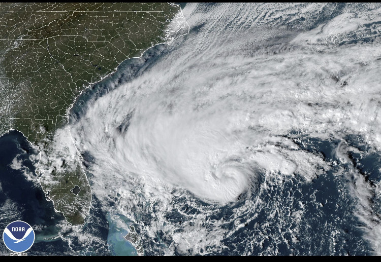
At 10 a.m., the storm was 25 miles (40 kilometers) east northeast of Great Abaco Island and about 210 miles (340 kilometers) east of West Palm Beach, Florida. With maximum sustained winds of 70 mph (110 kph), the storm was moving at 12 mph (19 kph).
In Florida, the “combination of a dangerous storm surge and the tide will cause normally dry areas near the coast to be flooded by rising waters moving inland from the shoreline,” the hurricane center’s 10 a.m. advisory said.
Brown said the storm will affect a large part of the state.

“Because the system is so large, really almost the entire east coast of Florida except the extreme southeastern part and the Keys is going to receive tropical storm force winds,” he said.
The storm is then expected to move across central and northern Florida into southern Georgia on Thursday, forecasters said. It was then forecast to move across the Carolinas on Friday.
“We are going to be concerned with rainfall as we get later into the week across portions of the southeastern United States and southern Appalachians, where there could be some flooding, flash flooding with that rainfall,” Brown said.
Early Wednesday, President Joe Biden declared an emergency in Florida and ordered federal assistance to supplement state, tribal and local response efforts to the approaching storm. The Federal Emergency Management Agency is still responding to those in need from Hurricane Ian.