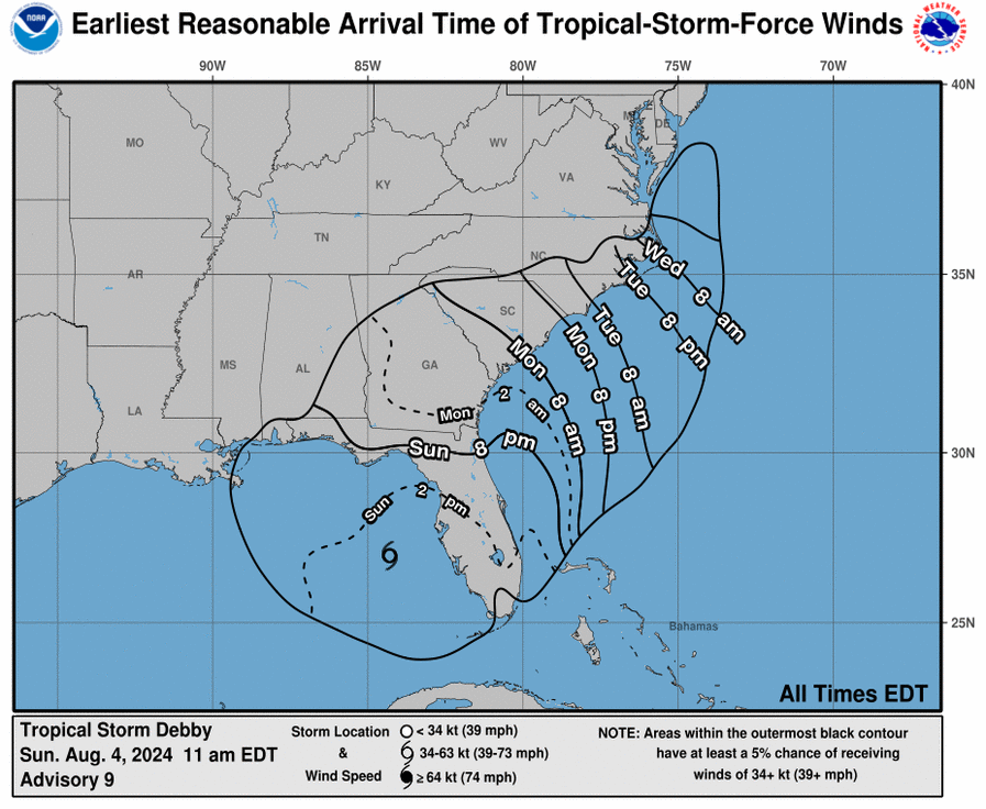
Tropical Storm Debby continues to plow through the Gulf of Mexico as the National Hurricane Center provided its late-morning advisory update showing the system is almost due west of Tampa Sunday.
The storm strengthened slightly at 11 a.m. as sustained winds climbed to 55 mph with gusts up to 65 mph. Those figures are about 5 mph greater than the 8 a.m. advisory from the National Hurricane Center. The system is spinning about 100 miles west of Tampa in the Gulf of Mexico and is moving north, northwest at 13 mph.
Debby is projected to strengthen to Category 1 hurricane status late Sunday, and forecasters say it is likely to make landfall overnight along the Big Bend stretch of Florida’s Gulf Coast. If the system intensifies to a Category 1 Hurricane, that means it will be packing winds of more than 75 mph.
In addition to winds, Hurricane Center officials say there are “potentially historic” rain events that could amount to 10 inches of precipitation. In addition, storm surges could threaten low-lying coastal areas with “6 to 10 feet of inundation.”
Debby is expected to make landfall at about 2 a.m. Monday in the Big Bend region of Florida, possibly north of Cedar Key and the trajectory after that will see the storm run inland along the Interstate 10 corridor in Florida. That would then lead the storm to cross inland into Georgia and possibly exit land areas around Savannah heading into the Atlantic Ocean, though North Florida communities are bracing for the impacts of the system. Shortly after the landfall, the system is expected to weaken to a tropical storm again.
Gov. Ron DeSantis has already declared a State of Emergency in Florida while President Joe Biden has declared most Florida counties will be eligible for disaster assistance from the Federal Emergency Management Agency.
While Debby appears likely to be heading toward Savannah, eventually, municipalities in South Carolina and North Carolina are already preparing for impacts from the storm if it continues to churn northward into Tuesday.


2 comments
Yrral
August 4, 2024 at 11:52 am
Debby could be a Cat 2 3,by tomorrow just like Beryl intensify,it has a whole day before it make landfall to intensify, almost 24 hours after this it could easily be a Cat 2 still at sea,Cuba is the only thing that stop from intensify ,want to know where Debby is close to you Google Zoom Earth
MarvinM
August 4, 2024 at 1:09 pm
And to think, the Heritage Foundation’s Project 2025 want to get rid of NOAA, altogether.
We get vital storm information from NOAA and its affiliate the National Hurricane Center.
I can’t imagine trying to navigate this without the information from these groups. It helps keep me and my family alive.
Comments are closed.