

Two newly formed tropical storms could become almost simultaneous threats to the U.S. Gulf Coast early next week. They could even get sucked into an odd dance around each other. Or they could fall apart as they soak the Caribbean and Mexico this weekend.
Tropical storms Laura and Marco have such bad and good environments ahead of them that their futures were not clear late Friday. Computer forecast models varied so much that some saw Laura becoming a major hurricane nearing the U.S., while others saw it dissipating.
If both storms survive the weekend, the National Hurricane Center forecast that Laura would as head a hurricane toward the central Gulf Coast around Louisiana, Mississippi, Alabama and the western Florida Panhandle, while Marco aimed at Texas, though most likely remaining a tropical storm.
“A lot of people are going to be impacted by rainfall and storm surge in the Gulf of Mexico,” said Joel Cline, the tropical program coordinator for the National Weather Service. “Since you simply don’t know you really need to make precautions.”
Two hurricanes have never appeared in the Gulf of Mexico at the same time, according to records going back to at least 1900, said Colorado State University hurricane researcher Phil Klotzbach. The last time two tropical storms were in the Gulf together was in 1959, he said.

Because the hurricane center slowed Laura’s entrance into the Gulf and moved its track westward, the two storms are now forecast to be together in the Gulf on Tuesday, just before Marco smacks Texas with Laura making landfall a bit less than a day later.
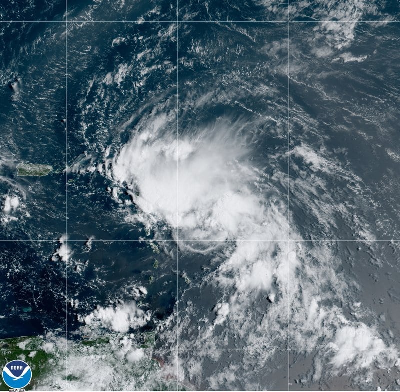
Tropical storm warnings were in effect early Saturday for Puerto Rico, the U.S. and British Virgin Islands and parts of the Dominican Republic. Laura was forecast to hit Puerto Rico on Saturday morning, go over or near the Dominican Republic and Haiti late Saturday and Cuba on Sunday.
Laura, which set a record for the earliest 12th named storm of a season when it formed Friday morning, was about 70 miles (110 kilometers) southeast of San Juan, Puerto Rico on Saturday morning. It had maximum sustained winds of 40 mph (65 kph) and was heading west at 21 mph (33 kph).
The hurricane center also issued a tropical storm warning and hurricane watch for part of Mexico’s Yucatan Peninsula for Marco, which grew into a tropical storm Friday night.
Saturday morning, Marco was centered about 115 miles (185 kilometers) east-southeast of Cozumel, Mexico, with maximum sustained winds of 45 mph (75 kph). It was headed north-northwest at 12 mph (19 kph).

If the two storms make it, they could be crowded in the Gulf of Mexico at the same time Tuesday about 550 miles apart. That would leave open some weird possibilities, including the storms rotating around each other in a tropical two-step, pulling in closer to each other, nudging each other, weakening each other or — far less likely — merging.
The last time two storms made landfall in the United States within 24 hours of each other was in 1933, Klotzbach said.
It seems fitting for 2020 to have this type of twin threats, said University of Miami hurricane researcher Brian McNoldy.
“Of course, we have to have two simultaneously land-falling hurricanes,” McNoldy said. “It’s best not to ask what’s next.”
On Friday morning, a hurricane-hunting airplane found Laura’s center to be dozens of miles farther south and better formed than satellite images showed. That triggered a shift in the forecast track, putting Caribbean islands more at risk and an upgrade to tropical storm status.
If Laura goes over land, Puerto Rico and the mountains of Haiti, the Dominican Republic and Cuba could tear it apart and not make it much of a threat to the mainland United States, meteorologists said. But if it misses or skirts land, it could head into warm waters conducive to strengthening as it approaches Florida, meteorologists said.
With competing scenarios, the hurricane center is forecasting a middle range for Laura of a weak hurricane heading into the eastern Gulf of Mexico.
Officials in the Florida Keys, which Laura might pass over on its route into the Gulf, declared a local state of emergency Friday and issued a mandatory evacuation order for anyone living on boats, in mobile homes and in campers. Tourists staying in hotels should be aware of hazardous weather conditions and consider altering their plans starting on Sunday, Monroe County officials said in a news release.
Citing both storm systems, Louisiana Gov. John Bel Edwards declared a state of emergency Friday night. “It is too soon to know exactly where, when or how these dual storms will affect Louisiana, but now is the time for our people to prepare for these storms,” Edwards said in a statement.
Meteorologists said Marco has a better chance of surviving its early land encounter, then strengthening to a minimal hurricane over warm water, but the hurricane center was forecasting it to weaken before it reaches the U.S. Gulf Coast because of decapitating high winds.