

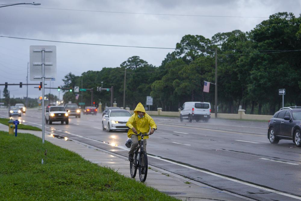
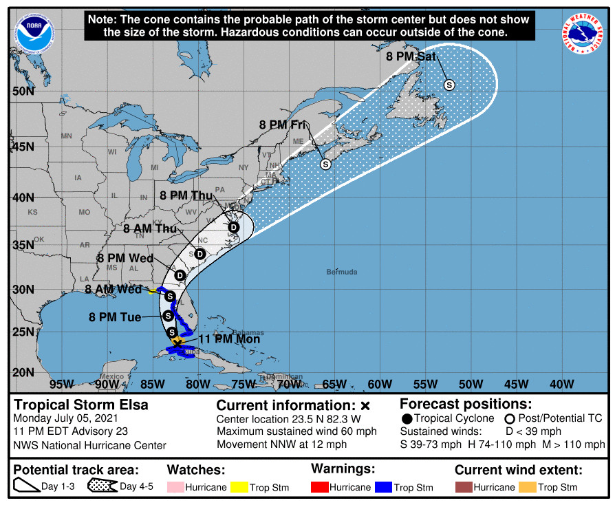
Tropical Storm Elsa brought severe weather to Florida even before making landfall in Taylor County. Now it has moved north into Georgia.
Florida Politics is tracking the storm’s progress, and this post will be updated frequently to represent the most up-to-date information as the state prepares for impacts.
6:30 a.m.
The state of Florida has attributed one fatality to Tropical Storm Elsa, the Associated Press reports.
A person was killed in Jacksonville after a tree fell and struck two cars. “Now is a time to remember … that weather is unpredictable,” Jacksonville Mayor Lenny Curry said during a news conference Wednesday evening. “This is really early in the (hurricane) season. We’re just outside of the July 4th holiday, we’ve had our first storm and, unfortunately, we’ve had a fatality.”

The city experienced wind gusts of 50 miles per hour at the time of the incident. No one else was injured.
8 p.m., Wednesday
There are no longer tropical storm winds from Tropical Storm Elsa impacting Florida communities, according to the National Hurricane Center. Parts of north Florida may continue to experience heavy rains. Meteorologists still expect one to three inches of rainfall in north Florida through the night. There remains some isolated threats of flooding in areas with poor drainage and saturated ground.
There are no longer tropical storm warnings or watches in the state of Florida. warnings are in effect for the full Georgia and South Carolina coasts, with watches extending into New England on the five-day forecast.
The storm now has sustained winds of 45 miles per hour and is moving north-northeast at 14 miles per hour. That means its path will not threaten the Jacksonville area as once feared.

As far as Florida, the state now enters recovery from a storm that ultimately delivered large amounts of rain to the state.

5 p.m., Wednesday
Tropical Storm Elsa has started moving into southern Georgia, according to the National Hurricane Center. The storm also continues to weaken, with maximum sustained winds of about 45 miles per hour. By comparison, the storm early this morning reached hurricane strength with 75 miles per hour winds.
All tropical storm warnings along Florida’s coast have been lifted. Meanwhile, warnings have been issued for communities on the Eastern Seaboard from Georgia to Massachusetts based on the five-day forecasts for the storm.
The center of Elsa now sits about 115 miles west-southwest of Brunswick Georgia, past the Florida-Georgia line. But Florida can still feel the impact of the storm, with storm force winds recorded 70 miles from the center. That means it still stretches further south than Lake City and McAlpin.

2 p.m., Wednesday
Tropical Storm Elsa is weakening as it continues to move across north Florida. A 2 p.m. advisory from the National Hurricane Center measures maximum sustained winds at 50 miles per hour.
The system is now about 105 miles west of Jacksonville and moving north at about 14 miles per hour.
At this point, all warnings of storm or storm surge conditions have been canceled south of the Suwanee River, but storm surge warnings remain between the Suwannee and Aucilla River, and tropical storm warnings extend to the Ochlockonee River.
Storm force winds now extend just 70 miles from the storm’s center, a smaller radius than when Elsa made landfall earlier today.
11 a.m., Wednesday
The National Hurricane Center confirms the storm is making landfall now in Taylor County, and that the storm continues to deliver 65 mile-per-hour sustained winds.
But from here on, the storm should weaken, and all hurricane warnings have been lifted from Florida’s west coast, though a tropical storm warning remains in effect. Meteorologists have also stopped all storm surge warnings for most of the west coast of the state, except for an area from Aripeka to the Aucilla River.
The storm maintains movement of around 14 miles per hour and continues on a due north path. Forecasters believe the system will turn to the east this afternoon.
Forecasts predict the storm will pick up speed as the day moves on, but it will remain on land cutting through the Southeastern U.S. through Thursday.
Tropical storm force winds still extend 90 miles from the center of the storm.
8:30 a.m., Wednesday
Gov. Ron DeSantis at a press conference in Tallahassee said the state has received 92 requests for assistance from communities impacted by Elsa; 57 of those have already been met or are being mobilized.
As of 6 a.m., around 26,000 customers reported power outages across Florida, most of those in Hillsborough, Pinellas and Polk counties. About 10,000 line workers are waiting for safe conditions to begin restoring power.
State officials have also stressed normal safety concerns. Those using generators should not use them inside. Those driving should not drive into moving water.
But no hospitals have lost power to date. There are concerns that the Big Bend area faces heightened risks of flooding because the land has been more saturated than normal in recent weeks.
8 a.m., Wednesday
Tropical Storm Elsa delivered heavy rain overnight to all of west Florida but has yet to make landfall in the state, according to the National Weather Service. The system right now sits around 35 miles west of Cedar Key.
Forecasters expect the storm to continue moving north until late afternoon, when models show it turning eastward to make landfall. It has sustained winds around 65 miles per hour, and is moving northward at 14 miles per hour. The storm strength is expected to stay the same until it moves onto land and begins to weaken.
Tropical storm force winds extend about 89 miles from the center of the storm and it’s likely storm surge will impact some normally dry areas of the state, causing flooding in the Big Bend area.
A forecast storm path shows a likely landfall somewhere between Perry and Suwanee, with winds already reaching deep inland as far as Gainesville.
Storm surge and tropical storm warnings have been lifted south of the middle of Longboat Key.

5 a.m., Wednesday
As bands of severe wind and rain strike communities along Florida’s west coast, Else moves on a trajectory almost parallel to the state’s coastline. But the National Hurricane Center has once again downgraded the system to a tropical storm and reports maximum sustained winds of 65 miles per hour.
A hurricane warning on Florida’s coast remains but for a smaller area, from Chassahowitzka north to the Steinhatchee River. A tropical storm warning runs now from south of Chassahowitzka to Englewood and from the Steinhatchee to the Ochlockonee River.
The storm continues to move at around 14 miles an hour due north over the warm waters of the Gulf of Mexico. The center of the system is now 70 miles west-northwest of Tampa and about 50 miles southwest of Cedar Key. Tropical storm force winds extend 90 miles from the center of the system.
Tropical storm warnings have been discontinued south of Englewood even as Southwest Florida continues to experience heavy rain. Inland communities also continue to experience heavy weather.
Forecasters expect the storm to make landfall late this morning or in early afternoon along the north Florida Gulf Coast, then to cut across the state and southeastern U.S.
11 p.m., Tuesday
Hurricane Elsa is maintaining sustained win speeds of 75 miles per hour. the category 1 storm continues to move northward just offshore from Tampa Bay, according to the latest National Hurricane Center update.
heavy rains and wind gusts are affecting both coastal and inland Southwest Florida and west Central Florida, which will continue.
While tropical storm warnings have lifted south of Chopoloskee and in the Dry Tortugas, a hurricane watch remains in place for much of the west coast of Florida.
Meanwhile, storm warnings have been extended along coasts in Georgia, South Carolina and North Carolina, a sign the stronger storm will continue to bring severe weather as it passes across Florida.
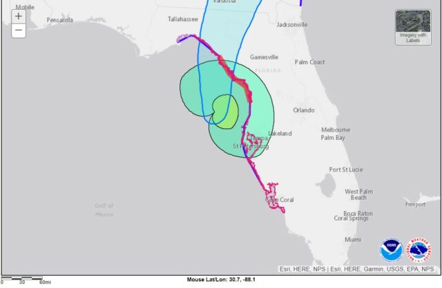
The storm has yet to make landfall in Florida, but is expected to do so overnight. But it will most likely pass Tampa Bay before doing so. The cone of uncertainty for the storm does still include parts of west Pinellas County, the storm path continues due north moving at 14 miles per hour.
The worst rain threats right now exists between Englewood and the Aucilla River, an area that includes all of Tampa Bay, where some areas could see three to five feet of storm surge.
8 p.m., Tuesday
With sustained winds of 75 miles per hour, Hurricane Else regained Category 1 Hurricane status as of the 8 p.m. advisory from the National Hurricane Center.
Located about 100 miles south-southwest of Tampa, the storm has also started to pick up speed, moving due north at roughly 14 miles per hour. Reconnaissance aircraft are en route to collect more data on the storm as it slowly climbs the Florida west coastline.
The center of the storm sits now roughly parallel with Cape Coral, and bands of heavy rain have delivered severe weather to communities for hours. A cone of uncertainty suggests the storm could make landfall as far south as Sarasota or as far north as Salem.
Hurricane force winds should be felt in mainland communities around 8 p.m. The storm could make landfall overnight.
The threat has largely moved beyond the Florid Keys, and tropical storm warnings have been lifted for the lower Keys. A hurricane warning remains in effect from Egmont Key to the Steinhatchee River.

5 p.m., Tuesday
While Tropical Storm Elsa right now has sustained winds of 70 miles per hour, the National Hurricane Center predicts hurricane force winds of 75 miles per hour or greater when the system makes landfall.
Gov. Ron DeSantis has added seven counties to the list of those under a state of emergency order. Additions include Baker, Bradford, Clay, Duval, Nassau, Putnam and Union.
As the storm nears shore, the area where meteorologists expect that landfall to happen has narrowed significant, with the cone of uncertainty stretching from the Perry-Salem area south to Bradenton.
With a stronger storm than expected coming onto land, tropical storm warnings have now been issued in Georgia in addition to coastal South Carolina.
With the storm passing the Keys, a tropical storm warning has been lifted east of the Seven Mile Bridge.

2 p.m., Tuesday
The National Hurricane Center reports that aircraft reconnaissance verifies stronger Tropical Elsa wind levels that previously believed. Meteorologists report 70 mile-per-hour sustained winds, just shy of hurricane-level strength of 75 miles per hour. In some areas, expect higher level gusts.
The storm now has moved about 95 miles northwest of Key West and its center has passed the Florida Keys. It sits now around 180 miles south of Tampa. It continues to move north-northwest at around 10 miles per hour.
11:55 p.m., Tuesday
The Florida Municipal Electric Association said it is closely monitoring the movement of Tropical Storm Else as it nears the Florida mainland, where it is expected to make landfall.
“Florida’s public power utilities have completed preparations for and are closely monitoring Tropical Storm Elsa, which is expected to make landfall along Florida’s Nature Coast early tomorrow morning,” said Executive Director Amy Zubaly.
“In preparation for the storm, the Florida Municipal Electric Association has activated its mutual aid network. Electric crews and resources from fellow public power utilities both within the state and from nearby states, including Georgia and Alabama, are on standby and ready to assist with power restoration efforts if needed. As in any emergency, public power is committed to restoring power as safely as quickly as possible for our customers.
“Our preparation efforts begin well before the start of hurricane season, and our mutual aid coordination efforts will continue right up until and immediately following landfall. We thank all the line workers and power restoration crews that are part of our mutual aid network for being at the ready to help impacted Florida communities.”
In other news, a Guardianship Improvement Task Force scheduled for Wednesday has been canceled.
11 a.m., Tuesday
Most of the Florida Keys continues to experience tropical storm force winds and heavy rainfall thanks to Tropical Storm Else. But the storm is passing the islands as it moves toward Florida’s west coast. As of an 11 a.m. advisory, the storm is 65 miles west-northwest of Key West.
The storm, with 60 mile-per-hour sustained winds, is moving across the Gulf of Mexico at a slower pace. It’s currently traveling around 10 miles per hour north-northwest.
As the forecast path of the storm skews further east, the National Hurricane Center has lifted a tropical storm watch in the Panhandle, from Ochlocknee River to Indian Pass, but a hurricane watch along most of Florida’s west coast is otherwise in effect.
While heavy rain and flash floods continue in Cuba, all storm warnings have been lifted there.
The storm could hue closer to the coast, and the cone of uncertainty shows Elsa could make landfall as far south as Charlotte County. Wherever it lands, forecasters expect winds and rain from Southwest Florida to the Big Bend over Tuesday and Wednesday.
8:30 a.m., Tuesday
At a press conference in Florida’s emergency operations center, Gov. Ron DeSantis said the state has moved to Readiness Level 1 in anticipation of Elsa’s landfall. But he stressed the storm remains a tropical storm, and said the heightened readiness has much to do with fiscally restrained counties being in areas under tropical storm watch and warning.
Department of Emergency Management Director Kevin Guthrie said about 250 members of the National Guard are on standby to respond to areas if necessary. Right now, only a handful of counties have asked for any resource support from the state. Water and staff support will be dispatched today and arrive before the storm makes landfall.
8 a.m., Tuesday
Tropical storm Elsa sits about 50 miles west of Key West, as of the 8 a.m. advisory from the National Hurricane center. As it moves across the warm waters of the Gulf of Mexico, it is expected to strengthen before making landfall on Florida’s west coast.
Meteorologists for now report sustained winds of 60 miles per hour, which is still tropical storm form strength. It’s expected to stay in that range, but a Hurricane Watch remains from Egmont Key to Steinhatchee River. All watches and warnings remain in place from the 5 a.m. advisory.
The storm is moving north-northwest at 12 miles per hour, and each forecast path released today has moved the potential course of the storm closer to Florida’s west coast. A cone of uncertainty looking at the potential for where Elsa makes landfall now stretches from north of Perry in the Big Bend to south of Venice in Southwest Florida.
5 a.m., Tuesday
While Elsa remains a tropical storm, a hurricane watch has now been issued by the National Hurricane Center for west-central Florida and the Big Bend. The area under watch extends from Egmont Key to the Steinhatchee River.
In Florida, storm surge warnings remain in effect from Bonita Beach to the Aucilla River, spanning all of the Tampa Bay region. A storm surge watch goes from the Aucilla to the Ochlockonee River.
On the eastern seaboard, a watch is now in effect on South Carolina’s coast from the mouth of St. Mary’s river to South Santee River showing the potential reach of the storm.
The system right now sits about 50 miles southwest of Key West, but it’s moving north-northwest at about 12 miles per hour, with sustained winds of 60 miles per hour.
The forecast path still has the storm making landfall after 2 a.m. on Wednesday, but the area that could potentially feel the brunt has shifted slightly south. The coastal area in the Hurricane Center’s cone of influence includes a huge area stretching north of Salem and south of Sarasota.
While there is a hurricane watch, forecasters still anticipate Elsa remaining a tropical storm when it hits land.

11 p.m., Monday
The National Hurricane Center reports the storm is back over water, though Cuba is still experiencing rain. As of 11 p.m., the storm was about 20 miles east of Havana, and more important to Florida, about 80 miles south of Key West.
Maximum sustained winds in the system have strengthened back to about 60 miles per hour. The storm is moving slower, at about 12 miles per hour in a northwest direction.
Elsa is right now expected to make landfall in the Panama City area around 8 a.m. on Wednesday.
8 p.m., Monday
The storm continues to deliver heavy rains on Cuba, as it has done for hours now, according to an 8 p.m. advisory from the National Hurricane Center.
Elsa has now passed about 30 miles east of Havana. Officials continue to report 50 mph sustained winds with the storm, which is moving northwest at 13 mph.
The center of the storm sits around 115 miles south of Key West, and forecasters predict it will move near the Keys on Tuesday. Winds should arrive on mainland Florida by 2 a.m. Tuesday.
But forecasts continue to show the storm slowing, which means it will sit in the Gulf of Mexico longer as it moves north alongside the coast of Florida. The current storm path projections show Elsa making landfall in the Big Bend area before 2 p.m. on Wednesday, with sustained tropical storm force winds.
5 p.m., Monday
Tropical Storm Elsa is continuing to travel over western Cuba and is now bringing heavy rains with it, according to the National Hurricane Center. Forecasters expect it to pass near the Florida Keys on Tuesday.
The storm as of a 5 p.m. advisory was 45 miles east of Havana and moving northwest at around 14 miles per hour. But sustained winds have dropped to about 50 miles per hour, still squarely in tropical storm territory.
In Florida, a storm surge warning has now been issued from Bonita Beach north to the Aucilla River. Meanwhile, a tropical storm warning has been extended northwestward to the Ochlocknee River.
But as the forecast storm path steers more toward North Florida, a tropical storm watch has been lifted for the Florida Keys north of Craig Key and for Florida Bay.
4:30 p.m., Monday
A number of school districts have canceled summer school classes and on-campus activities on Tuesday. That includes school districts in Alachua, Charlotte, DeSoto, Hardee, and Lee counties.
Pinellas and Taylor schools will close Tuesday and Wednesday. Pasco schools will close at 3 p.m. Tuesday and remain closed on Wednesday. Sarasota schools will close all week.
Some districts are not holding any summer classes or activities and others are closely monitoring the storm.
3:30 p.m., Monday
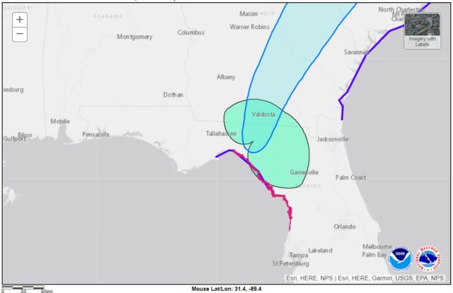
Gov. Ron DeSantis has declared a state of emergency in 15 additional Florida counties based on the forecast path for Tropical Storm Elsa. The newly added counties include Alachua, Columbia, Dixie, Franklin, Hamilton, Gilchrist, Jefferson, Lake, Lafayette, Madison, Marion, Sumter Suwanee, Taylor and Wakulla.
“There is an increasing threat to the Florida Big Bend and inland counties in North Florida,” the order reads in part.
The change comes as the National Hurricane Center predicts the storm’s path to make landfall in the Panama City area on Wednesday morning.
A state of emergency had already been declared in 15 other counties further south, including Charlotte, Citrus, Collier, DeSoto, Hardee, Hernando, Hillsborough, Lee, Levy, Manatee, Miami-Dade, Monroe, Pasco, Pinellas and Sarasota.
2 p.m., Monday
According to the National Hurricane Center, when Elsa made landfall in Cuba, it brought with it flooding rains. It hit the island nation on the south coast and the island’s west end.
The system is centered 85 miles southwest of Havana.
The wind speeds slowed after the storm reached land, around 60 miles per hour. It is continuing to move northwest at 14 miles per hour.
The 2 p.m. update from the Hurricane Center contained no updates to storm watches and warnings. Forecasts still show the storm making landfall around 8 a.m. On Wednesday morning in the Panama City area.
Officials expect the storm to weaken.
The Associated Press reports that Cubans experienced mild conditions on the island.
“So far, it’s a soft, serene rain. There are no downpours. The streets are not overflowing,” said Yolanda Tabío, a 73-year-old retiree living in Santiago. “I thought it could be worse.”
Still, the storm has claimed three lives to date, according to Caribbean Disaster Emergency Management Agency. That includes one person in St. Lucia, a 15-year-old boy, and a 75-year-old woman in the Dominican Republic.
11 a.m., Monday
Tropical storm warnings have been extended by the National Hurricane Center further northwest along Florida’s Gulf Coast.
The system sits 20 miles east-southeast of Cayo Largo, Cuba, and is moving northwest at 14 miles per hour. Sustained winds were measured around 65 miles per hour.
A tropical storm warning now extends north to the Suwanee River and south to Flamingo. There is also still a storm warning in the Florida Keys from Craig Key west to the Dry Tortugas.
A storm surge watch is in effect from Bonita Beach to the Ochlockonee River.
Meanwhile, a tropical storm watch is now in place from the Suwanee to Indian Pass. Watches remain in place in the Keys east of Craig Key to Ocean Reef and Florida Bay.
The storm made landfall in western Cuba and has largely passed over the island at this point. Cuba has discontinued all tropical storm watches and warnings.
Forecast storm paths show the storm moving slower, with a landfall predicted in the Big Bend area sometime early Wednesday morning. Forecasters expect it to remain a tropical storm when it hits Florida.
10 a.m., Monday
The entire state of Florida is facing a risk of flash flooding from Tropical Storm Elsa over the next three days. That’s according to projections from the National Hurricane Center.
As of an 8 a.m. advisory, Elsa is projected to make landfall in west-central Cuba but was still about 55 miles from Cayo Largo at the time. The hurricane, as of this morning, was already responsible for three deaths in the Caribbean. With maximum sustained winds of 65 miles per hour, it falls in the category of a Tropical Storm, but this weekend briefly had hurricane-force winds.
Gov. Ron DeSantis has declared a state of emergency in 15 Florida counties, including Charlotte, Citrus, Collier, DeSoto, Hardee, Hernando, Hillsborough, Lee, Levy, Manatee, Miami-Dade, Monroe, Pasco, Pinellas and Sarasota.
In Florida, the Hurricane Center issued tropical storm warnings in the Florida Keys from Craig Key west to the Dry Tortugas and in Southwest Florida from Flamingo north to Englewood. A tropical storm watch is also in effect from Craig Key to Ocean Reef and in Florida Bay and Englewood north to Aucilla River.
But much of the concern for Florida remains in the potential for flooding. There is a storm surge watch in effect from Bonita Beach north to the Suwanee River.
A hurricane watch by the Hurricane Center is in effect for the Cuban province of Camaguey. Tropical storm warnings are in effect on the island nation in Camaguey, Ciego de Avila, Sancti Spiritus, Villa Clara, Mayabeque and Havana.
Wind advisories predict the first storm-force winds could arrive in Florida as soon as 2 p.m. Monday in the Florida Keys and on the mainland before 8 p.m. Five-day projections on the storm track show the system moving through the Gulf of Mexico and making landfall in the Big Bend area sometime on Wednesday.
The Hurricane Center has discontinued Tropical Storm Watches for Cayman Brac and Little Cayman.
![[Image of WPC Flash Flooding/Excessive Rainfall Outlook]](https://www.nhc.noaa.gov/storm_graphics/AT05/refresh/AL0521WPCERO+gif/114917WPCERO_sm.gif)