

August wasn’t as busy as meteorologists anticipated, and now one major weather-focused outlet is revising its forecast for the remainder of hurricane season to predict fewer named storms.
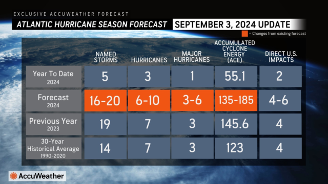
AccuWeather, a privately owned weather forecasting service headquartered in Pennsylvania, is now forecasting 16-20 named storms in the Atlantic basin, including 6-10 hurricanes of which 3-6 will be a Category 3 or higher.
That’s down from the “explosive” forecast AccuWeather published in late March that predicted 20-25 named storms, 8-12 hurricanes and 4-7 major hurricanes.
AccuWeather still predicts 4-6 named storms will have direct impacts on the United States through the end of November.
“Should the current lull continue deeper into September, reductions in the forecast number of named storms will be needed because a longer time period in the core of the hurricane season will have been devoid of named storms,” Jon Porter, chief meteorologist for AccuWeather, said in a statement.

Alex DaSilva, AccuWeather’s lead hurricane expert, noted this past Labor Day Weekend was an outlier for not having a named storm in the Atlantic basin. The last time that happened was in 1997.
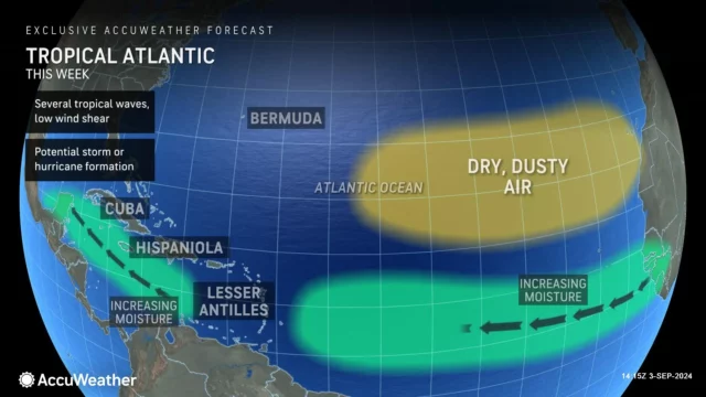
DaSilva attributed the absence of storm activity to “abundant amounts of dry air and Sahara dust in the Atlantic basin throughout August” and a slower-than-expected progression of a La Niña pattern.
“We’re also monitoring a large pocket of cold water off the western coast of Africa that is disrupting the tropical wave train,” he said in a statement. “Extremely warm waters across much of the Atlantic basin area (are) ideal for tropical development and rapid intensification, but the surge of dry air, dust, wind shear, and cold waters off the coast of Africa have prevented most tropical waves from developing into a tropical storm or a hurricane.”
As of Tuesday, when AccuWeather reduced its forecast, three of four spots in the U.S. that the service predicted would experience storm impacts had already done so, including Hurricane Beryl’s July landfall in Texas and Hurricane Debby’s collision with Florida’s Big Bend region last month, followed by the storm’s run across South Carolina.
As of Aug. 30, there have been $121 million worth of insured losses in Florida due to Hurricane Debby, according to the state’s Office of Insurance Regulation. AccuWeather estimated the total damage and economic loss to be $28 billion from Debby and $28-32 billion from Beryl.

Peak Atlantic Hurricane season is a week away. It runs Sept. 10 through Nov. 30. But according to Porter, extremely warm water temperatures this year could drive tropical threats into December.
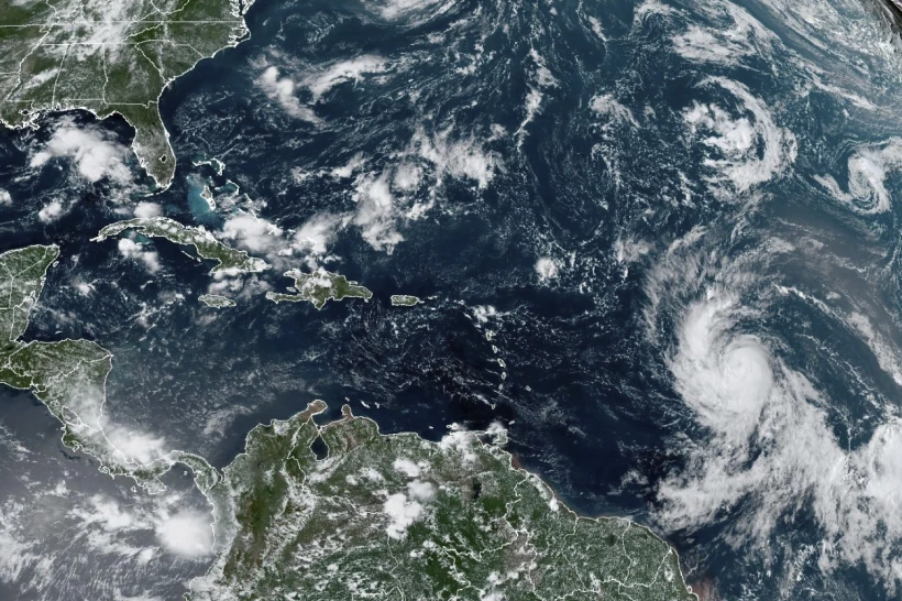
The proverbial calm now may soon end as the National Hurricane Center tracks three tropical waves in the Atlantic, all with potential bearings on the U.S. coastline.
There have been five named storms so far this season: Tropical Storm Alberto, which hit Texas in June; Hurricane Beryl, which made landfall in Texas in July; Tropical Storm Chris, which struck Mexico in July; Hurricane Debby, which tore across Florida and into South Carolina in August; and Hurricane Ernesto, which smacked into Puerto Rico late last month.
With two to four more direct impacts expected this season, Porter urged families, businesses, emergency officials and government leaders to restock supplies and prepare for worst-case scenarios now.
“We don’t want anyone to let their guard down even though we are now forecasting fewer storms in total,” he said. “With such extremely warm waters in much of the Atlantic basin, and more conducive conditions for tropical development expected in the coming weeks, it’s important that everyone is prepared for the threat of more storms this year. Those warm waters can act like jet fuel and help brewing storms explode in intensity. Rapid intensification near the coast is a major concern this Fall.”