

Storm surge warnings have all been lifted as Helene weakened and moved beyond the state of Florida.
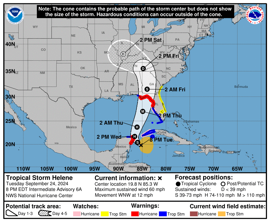
As of the 11 a.m. Friday advisory from the National Hurricane Center, Helene, now just a tropical storm, was centered 105 miles north-northeast of Atlanta. It now has sustained winds of 45 miles per hour, a significant diminishment 12 hours after Helene made landfall in the Big Bend as a Category 4 hurricane.
While tropical storm warnings are mainly in effect for parts of the Georgia and South Carolina coast north of the Savannah River, the NHC no longer has any coastal warnings in Florida.
5 a.m.
After making landfall in the Big Bend as a Category 4 hurricane, Tropical Storm Helene has weakened in strength and, as of 5 a.m. Friday morning, had sustained winds of around 70 miles per hour.

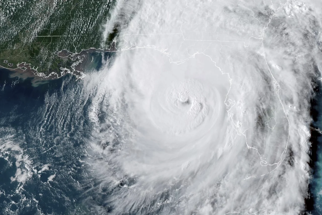
Helene ultimately moved ashore at 11:10 p.m. on Thursday near the Aucilla River in the Big Bend area. Its maximum sustained winds were estimated at 140 miles per hour. The path of the storm was similar to that of Hurricane Idalia last year, with the location about 20 miles northwest of where that storm came ashore.
The storm’s center has moved to Georgia, around 40 miles east of Macon, Georgia, as it continued to batter north Florida with storm-force winds, which extend 275 miles out from the center of the storm, mainly to the east. The National Hurricane Center said the storm still had 115 miles per hour of hurricane-force winds as the eye moved out of Florida into Valdosta, Georgia, early Friday morning.
“Continued weakening is expected, and Helene is expected to become a post-tropical low this afternoon or tonight,” a National Hurricane Center advisory reads. “However, the fast forward speed will allow strong, damaging winds, especially in gusts, to penetrate well inland across the southeastern United States, including over the higher terrain of the southern Appalachians.”
Most hurricane warnings have been lifted in Florida as the state turns attention to Helene’s aftermath. But storm surge warnings remain in Tampa Bay and from Indian Pass south to Bonita Beach on Florida’s Gulf Coast. A tropical storm warning remains from Indian Pass to the Suwannee River in Florida’s Panhandle and north of the Flagler-Volusia County line on Florida’s Atlantic coast.

11 p.m., Sept. 26

With 140 mph winds, Hurricane Helene will soon land near Big Bend. The storm is causing widespread flooding throughout Florida’s coast and the north through North Carolina.
The Category 4 storm, with its strong winds and catastrophic storm surge, is 40 miles from Tallahassee and 75 miles from Cedar Key.
“A turn toward the north is expected overnight, taking the center over Georgia,” the National Hurricane Center said during the 11 p.m. advisory.
Over a half million Floridians are without power, and thousands have evacuated.
The next update is scheduled for 2 a.m.
8 p.m.
Now officially a Category 4 hurricane, Helene is blowing up to 130 mph, and the National Hurricane Center warns it could gain more strength before it hits Florida on Thursday evening.
“Some additional strengthening is possible before the center reaches the coast in a few hours,” the NHC said in the 8 p.m. advisory, as the monster storm is currently 115 miles from Tallahassee.
Social media has shown images of heavy flooding in Sarasota and roads resembling rivers. Treasure Island Fire Rescue said it could not respond to any more calls now on Sunset Beach because of the worsening weather. Tampa Bay’s bridges are closed due to the dangerous conditions.
“Hurricane conditions are beginning within the hurricane warning area,” the NHC said. “When the eye comes ashore, people are reminded to not venture out into the relative calm, as hazardous winds will increase very quickly when the eye passes.”
5 p.m.
Hurricane Helene is now moving through the Gulf of Mexico with maximum sustained winds of 125 mph. That wind speed has been up by 15 mph since the 2 p.m. update from the National Hurricane Center, and it is just 6 mph short of gaining Category 4 status.
Watches and warnings remain unchanged per the 5 p.m. update. The storm is 130 miles west of Tampa and 175 miles south of Tallahassee. Helene is moving north-northeast at 23 mph.
The storm is expected to make landfall within hours.
2 p.m.
Hurricane Helene’s maximum winds are tracking at 110 mph, making it a Category 3 hurricane as the storm is expected to hit Florida’s Big Bend Thursday evening.
The hurricane is currently located 195 miles from Tampa, the National Hurricane Center’s 2 p.m. advisory said.
“Helene’s fast forward speed will allow strong, damaging winds, especially in gusts, to penetrate well inland across the southeastern United States, including over the higher terrain of the southern Appalachians,” the advisory said. “Helene is a very large hurricane. Hurricane-force winds extend outward up to 60 miles from the center and tropical-storm-force winds extend outward up to 345 miles.”
11 a.m.
Hurricane Helene continues to grow in strength as it follows a forecast path to the Florida Gulf Coast.
A National Hurricane Center advisory placed the storm 290 miles south of Apalachicola at 11 a.m. Eastern Standard Time. The center of the storm sits about 255 miles southwest of Tampa, and tropical storm force winds are now impacting the west half of the Florida peninsula from north of Tampa down to the Greater Miami area.
“Tropical storm conditions have already begun in the Florida Keys and portions of south Florida, and these conditions are expected to spread northward across the tropical storm warning areas in the southeastern U.S. through early Friday,” the advisory reads. “Strong, damaging winds, especially in gusts, will likely penetrate as far inland as the higher terrain of the southern Appalachians.”
Forecasters warned the hurricane represents a life-threatening situation, and that it will be a major hurricane of greater than Category 3 strength when it makes landfall, likely this evening.
It currently has maximum sustained winds of 105 miles per hour, remaining a Category 2 hurricane.
The entire state of Florida is expected to feel the wind impact of the storm system.
8 a.m.
Hurricane Helene has reached Category 2 strength as it makes its way across the Gulf of Mexico on a path to Florida.
The National Hurricane Center in its latest advisory said the storm now has maximum sustained winds of 100 miles per hour. Forecasts show it will continue to increase in force and reach greater than Category 3 strength before making landfall.
The center of the storm as of 8 a.m. (Eastern Standard Time) was 320 miles southwest of Tampa and 365 miles south of Apalachicola, and it appears to be moving north-northeast at 12 miles per hour.
“This general motion is expected to continue with a significant increase in forward speed during the next 24 hours,” an advisory reads. “On the forecast track, Helene will move across the eastern Gulf of Mexico today and cross the Florida Big Bend coast this evening or early Friday morning. After landfall, Helene is expected to turn northwestward and slow down over the Tennessee Valley on Friday and Saturday.”
Hurricane warnings remain in place for coastal communities in Mexico City in the Florida Panhandle south to the Anclote River in Tarpon Springs. Storm surge warnings extend all the way to Flamingo in South Florida.
Hurricane force winds extend 60 miles from the center of the storm, and tropical storm winds have already been reported in Southwest Florida and Tampa Bay. A station in Key West has detected gusts as strong as 55 miles per hour.
The center advises a high risk of tornadoes today that will increase all night in parts of North Florida.
5 a.m.
An early morning advisory from the Hurricane Center shows Hurricane Helene slowly gaining power and briskly crossing the Gulf of Mexico.
As of a 5 a.m. advisory, the National Hurricane Center warned the storm will deliver “catastrophic winds and storm surge to the Northeast Gulf Coast.” The agency said any preparations for the storm should be “rushed to completion” this morning as areas in the path of the hurricane brace for impact.
Helene remains a Category 1 storm with sustained winds of 90 miles per hour, While still 350 miles southwest of Tampa and 385 miles south of Apalachicola, the center of the storm is moving at a rate of 12 miles per hour toward the coast.
“This general motion is expected to continue with a significant increase in forward speed during the next 24 hours,” an advisory reads. “On the forecast track, Helene will move across the eastern Gulf of Mexico today and cross the Florida Big Bend coast this evening or early Friday morning. After landfall, Helene is expected to turn northwestward and slow down over the Tennessee Valley on Friday and Saturday.”
The storm is expected to reach Category 3 strength, with winds greater than 111 miles per hour, well before the eye makes landfall. Hurricane-force winds can be detected 60 miles out from the center of this storm
The Key West Naval Station has already reported tropical storm winds, with wind gusts of up to 64 miles per hour.
A chief early concern remains storm surge, which is expected as far south as Charlotte Harbor under current models. The agency said Florida regions should brace for substantial rises in water levels. That latest advisory offered the following peak storm surge forecasts in the following areas:
— Carrabelle to Suwannee River: 15-20 feet.
— Apalachicola to Carrabelle: 10-15 feet.
— Suwannee River to Chassahowitzka: 10-15 feet.
— Chassahowitzka to Anclote River: 8-12 feet.
— Indian Pass to Apalachicola: 6-10 feet.
— Anclote River to Middle of Longboat Key: 5-8 feet.
— Tampa Bay: 5-8 feet.
— Middle of Longboat Key to Englewood: 4-7 feet.
— East of Mexico Beach to Indian Pass: 3-5 feet.
— Englewood to Flamingo: 3-5 feet.
— Charlotte Harbor: 3-5 feet.
11 p.m., Sept. 25
Hurricane Helene is gaining power as the dangerous storm is projected to travel across the Gulf of Mexico Wednesday night and hit landfall as a Category 4 storm.
The National Hurricane Center’s (NHC) 11 p.m. update showed the hurricane about 425 miles from Tampa.
“Maximum sustained winds are near 85 mph with higher gusts,” the NHC said. “Strengthening is forecast, and Helene is expected to be a major hurricane when it reaches the Florida Big Bend coast Thursday evening.”
The NHC warned about deadly storm surges that could reach up to 20 feet in some areas, flooding and the possibility of tornadoes.
In preparation, Gov. Ron DeSantis declared a state of emergency in 41 of the state’s 67 counties.
8 p.m., Sept. 25
Tampa Bay remains under a hurricane watch as Hurricane Helene is expected to make landfall Thursday evening, according to the National Hurricane Center’s (NHC) 8 p.m. update.
“A Hurricane Watch means that hurricane conditions are possible within the watch area. A watch is typically issued 48 hours before the anticipated first occurrence of tropical-storm-force winds, conditions that make outside preparations difficult or dangerous,” the NHC said.
The watch extends for a 110-mile stretch from Englewood to Anclote River, which includes Tampa Bay.
“Helene is moving toward the north near 12 mph,” the update said. “On the forecast track, Helene will move across the eastern Gulf of Mexico tonight and Thursday and cross the Florida Big Bend coast Thursday evening. After landfall, Helene is expected to turn northwestward and slow down over the Tennessee Valley on Friday and Saturday.”
Many of Florida’s businesses and schools are shutting down Thursday as forecasters warn the storm will be powerful and hit land as a Category 4. Another dangerous threat is the storm surge, which could be 3 to 5 feet in Tampa Bay and up to 20 feet in the Panhandle area near Carrabelle.
5 p.m., Sept. 25
National Hurricane Center Deputy Director Jamie Rhome said Wednesday evening that Hurricane Helene is intensifying and is expected to hit Florida as a Category 4 storm on Thursday.
“Let’s call out a few cities that are in the path here. Tallahassee, unfortunately, you’re going to be right in the path of these catastrophic winds,” Rhome said.
The NHC’s 5 p.m. advisory still shows Helene as a Category 1 hurricane with 85 mph sustained winds about 460 miles southwest of Tampa and 505 miles south-southwest of Apalachicola as it moves north at 12 mph.
The forecast shows it is moving north, where it is projected to gain power in the Gulf of Mexico.
He spoke with a sense of urgency as Florida’s west coast is at risk for storm surge.
“Let’s talk about first, the Big Bend area, 15 to 20 feet,” he said. “Now I’ve been here for 25 years. We don’t normally forecast surge values this big, so this is pretty significant.”
“Let’s look at Tampa. Five to eight feet of storm surge,” he added. “You need to think about what you need to stay home for several days. Get it and do it tonight, not tomorrow. Tonight. For many of you, you’re starting to run out of time, so the time to act is now.”
2 p.m., Sept. 25
The latest advisory from the National Hurricane Center shows little change in forecasts for Hurricane Helene, a Category 1 storm expected to reach Florida’s coast on Thursday.
The center of the storm is currently 480 miles south-southwest of Tampa, and the system continues to move toward Florida at around 10 miles per hour.
“A turn toward the north and north-northeast with an increase in forward speed is expected later today through Thursday, bringing the center of Helene across the eastern Gulf of Mexico and to the Florida Big Bend coast by Thursday evening,” a 2 p.m. storm advisory reads.
The center advises that any precautions to protect life or property should be completed today.
11 a.m., Sept. 25
The National Hurricane Center said a storm threatening Florida’s Gulf Coast has reached hurricane strength.
The center of Hurricane Helene as of 11 a.m. Wednesday was 85 miles north-northeast of Cozumel and 500 miles south-southwest of Tampa, but forecasts have it on track to make landfall in the Florida Panhandle as a major hurricane around 7 p.m. Thursday. The storm is moving toward Florida at about 10 miles per hour.
The storm now has maximum sustained winds of 80 miles per hour, which is in the range for a Category 1 storm. However, forecasts show that it will be greater than Category 3 by the time it reaches Florida.
“Additional strengthening is forecast, and Helene is expected to be a major hurricane when it
reaches the Florida Big Bend coast Thursday evening,” an advisory reads. “Weakening is expected after landfall, but Helene’s fast forward speed will allow strong, damaging winds, especially in gusts, to penetrate well inland across the southeastern United States, including over the higher terrain of the southern Appalachians.”
A tropical storm warning has now been extended west to the Okaloosa-Walton county line, and a storm surge watch now covers Mexico Beach to Indian Pass. A storm surge warning, meanwhile, extends from Indian Pass all the way to Flamingo in South Florida, covering the coastal water bodies of Tampa Bay and Charlotte Harbor.
A hurricane warning covers coastal areas from Mexico Beach to the Anclote River in Tarpon Springs.
Additionally, tropical storm warnings are in place for all of the Florida Keys and the Dry Tortugas, from the Anclote south to Flamingo, west of Mexico Beach to the Walton-Bay county line, and the entire east coast of Florida south of the St. Mary’s River, as well as all communities on the shore of Lake Okeechobee.
6 a.m., Sept. 25
Tropical Storm Helene is expected to strengthen to hurricane force early today as it drenches the Yucatán Peninsula in Mexico. From there, forecasts show the storm moving northeast into the Gulf of Mexico and gaining strength before moving toward Florida.
A 5 a.m. advisory from the National Hurricane Center includes a similar projected storm path as seen since the system first formed as a cyclone earlier in the week. The storm earlier this morning was centered less than 50 miles from Cozumel, and heading northwest at 9 miles an hour.
Hurricane Hunter planes say the storm currently has maximum sustained winds of around 65 miles an hour. When those winds pick up speed to 74 miles per hour, it will officially become a hurricane.
“On the forecast track, the center of Helene will pass near the northeastern coast of the Yucatán Peninsula this morning, move across the eastern Gulf of Mexico later today and Thursday, and reach the Big Bend coast of Florida late Thursday,” an advisory reads.
A storm surge warning is in effect for Indian Pass in the Panhandle south to Flamingo, and covers the vulnerable coastal areas of Tampa Bay and Charlotte Harbor.
A hurricane warning now covers the area from the Anclote River in Tarpon Springs to Mexico Beach in the Panhandle. The area from the Anclote south to Englewood is under a hurricane watch.
Additionally, tropical storm warnings are in place for all of the Florida Keys and the Dry Tortugas, from the Anclote south to Flamingo, west of Mexico Beach to the Walton-Bay county line, and the entire east coast of Florida south of the St. Mary’s River, as well as all communities on the shore of Lake Okeechobee.
From Tuesday
Tropical Storm Helene continues to strengthen as it moves toward the Gulf of Mexico on its way to landfall on the Florida coast Thursday. Still a tropical storm, Helene now has maximum sustained winds of 60 miles per hour, according to the National Hurricane Center in a 8 p.m. advisory.
The system remains on course to make landfall in the Panhandle as a hurricane on Thursday evening.
Storm surge warnings are in place from Indian Pass near Panama City south to the southernmost point of the Everglades. Tampa Bay and Charlotte Harbor are also under a storm surge warning.
Hurricane warnings are in place in coastal areas from the Anclote River to Mexico Beach. Hurricane watches are in effect from Englewood to the Anclote River, and Tampa Bay. Tropical storm warnings are in place for the lower and middle Florida Keys west of the Channel 5 Bridge; from Flamingo to the Anclote River, including Tampa Bay; and west of Mexico Beach to the Walton/Bay County line.
Further inland and toward Florida’s east coast, tropical storm watches are in effect for Lake Okeechobee and from the Palm Beach/Martin County line north to the Savannah River.
The track and timing for the storm’s impacts to Florida and eventual landfall have changed little throughout the day, with the storm expected to turn toward the northwest later Tuesday night, followed by general northward motion into Wednesday through Friday. The storm is expected to pass near the northeastern coast of the Yucatán Peninsula on Wednesday, before moving across the eastern Gulf of Mexico into Thursday, with landfall expected in the Big Bend coastal area sometime late Thursday.
Helene is expected to reach hurricane strength sometime early Wednesday when it will rapidly strengthen into a major hurricane on Thursday.
As of the 8 p.m. advisory, tropical storm force winds extend from the center of the storm east up to 175 miles.
“The combination of a dangerous storm surge and the tide will cause normally dry areas near the coast to be flooded by rising waters moving inland from the shoreline,” the advisory warns.
Historic storm surge levels are predicted, with the highest totals expected from the Ochlockonee River to Chassahowitzka, at 10-15 feet. From Chassahowitzka to the Anclote River, storm surge could reach 6-10 feet, while the area of Indian pass to Ochlockonee River is estimated to see a surge of 5-10 feet. Tampa Bay could see 5-8 feet of storm surge, with storm surge totals getting lower in more southern areas of the state, including the lowest expected levels of 3-5 feet in Charlotte Harbor and from Englewood to the Everglades.
The Division of Emergency Management has urged preparation for the storm system.
“Potential Tropical Cyclone 9 may impact Florida later this week. Prepare your home NOW. If you can pick it up, put it up,” reads a message on the agency’s social media. “Anything left outside of your home can become dangerous debris in high winds. Continue to monitor the weather & listen to all orders by local officials.”
4 comments
The Sage "E" [FKA ELVIS - FKA EARL]
September 24, 2024 at 9:37 pm
All Floridians, even The Dook 4 Brains Leftys, are so greatfull we have Ron & Casey in charge rather than some “Slack- Jawed” useless Democrat.
Thank you Greatfull Floridians,
The Sage “E” [FKA ELVIS – FKA EARL]
Billy Rotberg
September 25, 2024 at 9:50 am
Please be careful everyone!
A Day without MAGA
September 25, 2024 at 10:13 am
I told you about this storm 10 days ago,while I was checking various models,the good and bad news,it not hitting a major Florida city such as Miami and Tampa, Tallahassee will be in the eyewall 36 hours from now
A Day without MAGA
September 25, 2024 at 2:00 pm
The European model got the track east of Tallahassee,while the NHC track is tracking westward,the European model got it a Cat 1 near Tallahassee
Comments are closed.