

U.S. Sen. Marco Rubio says the forecast for Hurricane Milton’s path and impacts are a dead ringer for a worst-case scenario he requested a while back.
Hurricane Milton strengthened rapidly Monday from a Category 2 storm to Category 5 strength, with sustained winds at 175 mph, within a matter of hours.
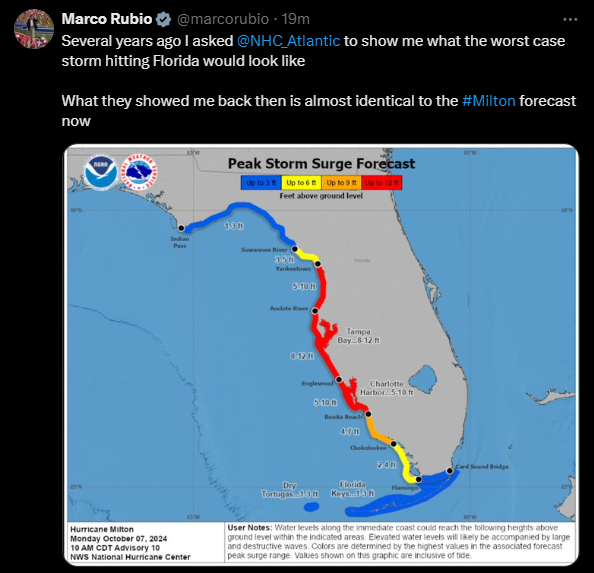
Posting a National Hurricane Center map of peak storm surge expectations to X at 2:30 p.m. that showed flooding of between 3 and 12 feet across the entire Gulf Coast and the Keys, Rubio provided a chilling outlook.
“Several years ago, I asked (the National Hurricane Center) to show me what the worst case storm hitting Florida would look like,” he wrote. “What they showed me back then is almost identical to the #Milton forecast now.”
Milton is on a collision course with the Tampa Bay area, threatening deadly flooding there and across the same stretch of coastline that Hurricane Helene swamped less than two weeks ago.

Gov. Ron DeSantis on Monday urged localities to clear debris still sitting in the open after Helene to clean the messes up before Milton strikes. The storm could come ashore Wednesday, and its forceful winds could sweep up loose pieces and turn them into projectiles that could cause more damage and add to the at least 230 deaths due to Helene.
Milton’s intensification in wind speed by 92 mph (148 kph) in 24 hours trails only those of Hurricane Wilma in 2005 and Hurricane Felix in 2007. One reason Milton strengthened so rapidly is its small size, with a “pinhole eye,” just like Wilma’s, said Colorado State University hurricane researcher Phil Klotzbach.
The storm likely will have to go through what’s called an eyewall replacement cycle, a natural process that forms a new eye and expands the storm in size but weakens its wind speeds, Klotzbach said.
The Gulf of Mexico is unusually warm right now, so “the fuel is just there,” and Milton probably went over an extra-warm eddy that helped goose it further, said University of Albany hurricane scientist Kristen Corbosiero.
The hurricane center forecasts a slight weakening before landfall in Florida. The last hurricane to be a Category 5 at landfall in the mainland U.S. was Michael in 2018.

___
Material from The Associated Press was used in this report. Republished with permission.
8 comments
Kamala is Brat 🌴🥥🌴
October 7, 2024 at 3:13 pm
“Let’s not fix Florida’s broken insurance laws or the national immigration policies ….. let’s simply get out our hurricane Sharpies and pray!
A Day without MAGA
October 7, 2024 at 3:17 pm
The best thing to do is to head to Miami area, Tampa is in the eyewall and people 30 miles from Tampa will get the intense wind,Marco Rubio come to.Jesus moment in the climate
Joe
October 7, 2024 at 3:47 pm
Too bad Floridians don’t have anyone in their political leadership that they can rely on when things go wrong. Thanks MAGA morons!
A day without Libturds
October 7, 2024 at 3:55 pm
More pathetic libturd bs
Tjb
October 7, 2024 at 6:56 pm
Did Marco vote against additional funding for FEMA?
Michael K
October 7, 2024 at 9:59 pm
Byron Daniel’s voted against. Rick Scott couldn’t be bothered to vote. Though Marco has voted against FEMA in the past, he did vote for the current funding, joining all Democrats.
Cindy
October 7, 2024 at 8:07 pm
Milton close to 200 mile and hour tornado 🌪️ winds.. hitting Tampa Riverview
Dont Say FLA
October 8, 2024 at 7:24 am
The Democrats control the weather. It’s their new strategery for trying to run the Turnip J Truck into the ditch. Looks like this one may miss Mag-a-Lardo, but the third time’s always a charm.
Big apologies from the Democrat Weather Makers to the 52% of Florida who would prefer Donald J Truck and all his turnips went away after their last defeat.
After the ex-MAGA agents’ failures, we had no choice but hurricanes. We figure y’all in the 52% are smart enough to leave when hurricanes come to
townthe entire peninsula. Please make our figuring be right. TYVMComments are closed.