

Last updated: 5:45 p.m.
When it comes to hurricanes, Jacksonville has had a lot of dry runs, false alarms, and close calls.
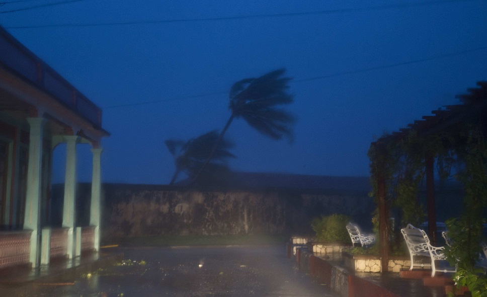
Hurricane Matthew is different.
NOAA said as much in its noon Thursday update: “A major hurricane has not impacted this area in 118 years, since Oct. 2 1898. There is NO local living memory of the potential of this event. If a direct landfall occurs this will be unlike any hurricane in the modern era.”
Mayor Lenny Curry said as much also.

“This is a 100-year storm. We have not seen a storm like this in our lifetime,” Curry said in his 11:30 update.
For one thing, evacuations already have been ordered for the beaches and low-lying, flood-prone areas, well ahead of storm impacts.
It was, as of Thursday afternoon, uncertain if those evacuation orders were followed promptly. Despite jammed roadways, only 30 percent of beaches residents had left at 4 p.m.
The storm is expected to impact the Jacksonville area late tonight and into Friday, with an existential threat during the late hours Friday evening.
For another thing, rather than the usual drill of the sheriff’s office suggesting bridges may be closed at some point, law enforcement told local media that bridges would be closed without warning.

Shelters, which seemed like an abstract concept in many previous close calls, were a more concrete need.
Four were opened: The Legends Center, Atlantic Coast High School, Twin Lakes Elementary School, and Landmark Middle School. As well, LaVilla may open later today.
As of Thursday evening, there was plenty of room in all of them.
On Thursday morning, National Weather Service Incident Meteorologist Angie Enyedi joined Mayor Lenny Curry for the first of five situational updates.
Curry reiterated and expanded his evacuation order.
“If you are in Zone A or B, call it what you want: this is a direct order. To show you how serious this is, I am adding Zone C to the evacuation order.”
Duval residents: to discern your zones, click here. There is a good chance you are in one of the zones affected. Zone A contains 192,000 residents, as does Zone C. Zone B has 72,000.
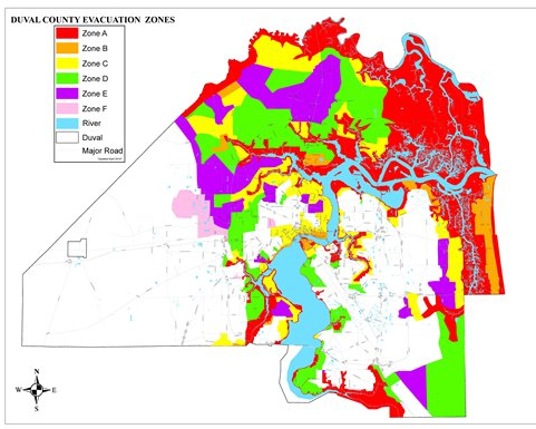
All told, 456,000 residents of flood-prone areas are strongly advised to leave before the storm hits.
As well, a 5:00 p.m autodial from the city of Jacksonville noted that those living in manufactured homes are compelled to evacuate.
All evacuees were compelled to be “in a safe place” by midnight Thursday night.
“This is about your life. This is about your family right now. If you’re in these zones, leave,” Curry said. “You very likely will be on your own for a period of time.”
The city will not enforce evacuation orders, in terms of sending police to people’s homes; however, the recommendation was issued repeatedly in the strongest possible terms.
For those not evacuating and filling their cars’ gas tanks, Curry advised them to take the fuel they need, to allow supply for those leaving town.
Evacuations are proceeding, with many headed westbound on Interstate 10, albeit very slowly.
Curry noted at 8:30 a.m. the city does not offer sandbags, and said he expected weather to deteriorate around midnight Thursday.
Curry and Sheriff Mike Williams stressed the urgency of timely evacuations, with Williams saying “at some point, we’ll all have to hunker down.”
“Traffic’s light right now, it’s been light all morning,” Williams said. “Take advantage of the opportunity.”
Meanwhile, JEA expects widespread outages and customers should be prepared for multiple days without services.
Crews will be working to restore any outages that occur prior to the main body of the storm until winds reach a 30 mph sustained level.
JEA will suspend water and sewage to all customers east of the Intracoastal ordered to evacuate beginning Thursday at 8 p.m.
In the 11:30 a.m. update, Curry noted that food, water, and service crews will be available post-storm, in what looks to be a genuine disaster recovery effort in the making.
Enyedi noted winds are expected between 90 and 100 mph at the coast, with gusts up to 130 mph.
In the western part of the county, sustained winds of up to 90 mph are expected.
This will be the storm, the meterologist said, that “our generation will talk about.”
Update at 2:30 — A flood is forecast. And National Guardsmen will be in the street during the aftermath.
A 6-to-9-foot storm surge is predicted downtown tomorrow, with a 3-to-6-foot rise in the Ortega River. Compounded with historic flooding expected in Jacksonville Beach, this is forecast to be a catastrophic event for Duval County.
“National Guard assets in and around the city” and a “heavy presence of National Guard assets at the beaches” start Saturday, said Sheriff Mike Williams, helming a rare media update without the mayor present.
“Stop-and-go traffic” can be found on all the major evacuation routes, Williams added.
Minor alternate routes west out of town are suggested, such as taking Normandy to 301 or U.S. 90 toward Baldwin.
Tropical Storm force winds should begin at 6 a.m. Friday, with sustained hurricane-force winds from 1 to 4 p.m, said Enyedi.
In one bright spot, the Mayor’s Office reported that, as of 3 p.m., the Jacksonville International Airport is still open.
One suspects, however, that will change within hours.
5:40 Update: “I keep hoping I’ll hear some good news and this track will change. That is not the case. This is going to be a catastrophic storm,” Curry said.
The mayor pleaded with those in evacuation zones to leave.
“At some point, in the very near term, you will ask yourself, ‘why didn’t I leave?’,” Curry said.
Garbage pickup will resume on Sunday.
The weather forecast did not change substantially from previous forecasts Thursday.
High-rise buildings are especially susceptible to wind damage.
Inland, 60 to 80 mph winds are expected. At the coast, conditions will be worse.
Meanwhile, the sheriff said traffic has abated on evacuation routes from earlier in the afternoon, advising people to be where they are trying to be before midnight.
Finally, Mayor Curry thanked the governor and President Obama for their efforts, including Obama’s emergency declaration.
“We’re all in this together,” Curry said.
To those who ignored his urging to evacuate, Curry advised them to “hunker down” and “expect power outages.”
When asked, Curry said he would not impose a curfew.