
Political boundaries can’t be seen by the naked eye, but they significantly impact the governance of the state. This week, the Florida Legislature passed once-a-decade legislation reconfiguring 40 Senate and 120 House districts. With those moves, lawmakers created opportunities for some candidates and established roadblocks for others, driving decisions that in many cases directly impact sitting members’ careers.
Maps still must undergo review by the Florida Supreme Court, a process that should be complete before the end of Session.
But a decade ago, all maps cleared that high-level review, even the Senate map that was eventually tossed after years of litigation. Most likely, the cartography approved by each chamber will govern elections in the 2022 election cycle, and the plan is for these lines to stay in place through the 2030 races.
So, what has changed from the last time candidates qualified for legislative races?
Strap in for the ultimate political tour of Florida’s legislative districts, established for a decade — or until a judge orders them to be changed again.
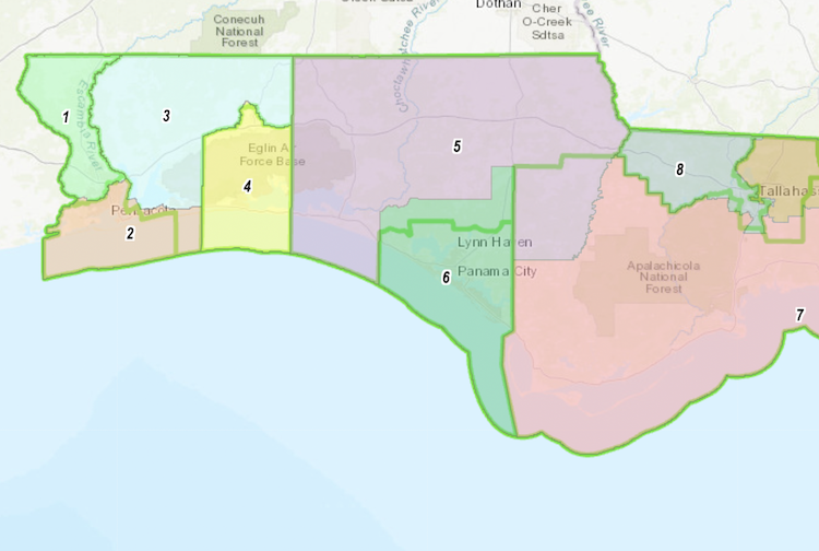
(All maps via FloridaRedistricting.gov. Green lines show outgoing benchmark House district bounds and blue ones show the soon-to-retire Senate lines.)
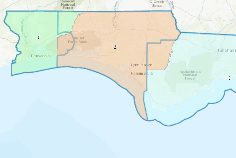
Panhandle privilege: Living in Florida’s westernmost communities means never learning new district numbers. A phenomenon best explained by the tendency to read from left to right means Florida’s Panhandle saw fewer dramatic shifts than any region of the state regarding new districts. On the Senate map (S 8058), some land changes hands between SD 1 and SD 2. Most of Eglin Air Force Base, but not all, now falls into SD 2, while the west district picks up a substantial piece of north Okaloosa County in return — basically everything north of State Road 1 and east of Highway 85. The change splits Crestview between the districts. Meanwhile, SD 2 on its western boundary peels Calhoun County away from SD 3.
On the House map (H 8013), the border smooths almost unnoticeably between HD 1 and HD 2, but HD 3 withdraws entirely away from the coast. Most territory south of East Bay now falls into the Pensacola-based HD 2, with Navarre Parkway serving as the divide between the districts stretching from that water body straight to the Okaloosa County line. Crestview now falls entirely within HD 4. Further inland, the old border for HD 6 now encompasses all of Bay County and nothing but Bay County. That means swiping some land back from HD 5. But the northern district makes it up, much like SD 2, by snatching all of Calhoun County away from its Big Bend neighbors.
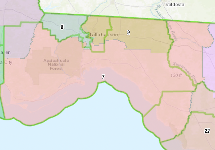
Tallahassee two ways: In maybe the most significant victories for Democrats in redistricting, Tallahassee officials lobbied to keep the Capital City split between just two House districts. The easternmost part of the city is in HD 8, a minority seat represented by Democratic Leader Designate Ramon Alexander. HD 9, represented by Democrat Allison Tant, does pick up part of Central Tallahassee, cutting south to Magnolia Drive. A leg of the district extends west to cover Florida State University, with Academic Way largely serving as a north border to that segment of HD 9. Some of HD 7, a seat held by Republican Jason Shoaf, picks up pieces of Tant’s and Alexander’s existing districts — mainly the Woodville area and communities around Apalachicola National Forest. But the rural district steers clear of the city. That leads to quite a bit of Shoaf’s district along the Florida-Georgia line shifting into HD 9. The proposed HD 9 extends east to the Suwanee and Withlacoochee rivers to encompass all of Jefferson and Madison counties. HD 7 also reaches further east, gobbling up Hamilton, Suwanee and Dixie counties into the jurisdiction.
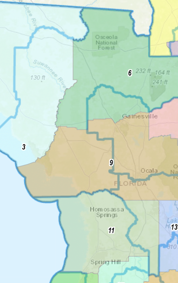
Bending big: In the Senate, the existing SD 5 gets the knife. With SD 3 absorbing Suwannee, Lafayette and Dixie counties, proposed SD 6 spans far enough to sweep up Columbia and Gilchrist counties and carve into Alachua. This lumped Sens. Keith Perry of Gainesville and Dennis Baxley of Ocala into one district. Baxley has said, however, he would move out of the proposed SD 9, which includes south Gainesville as well as all of Marion and Levy counties. Citrus County lands in proposed SD 11, along with Sumter County and a touch of Pasco south to Hudson.
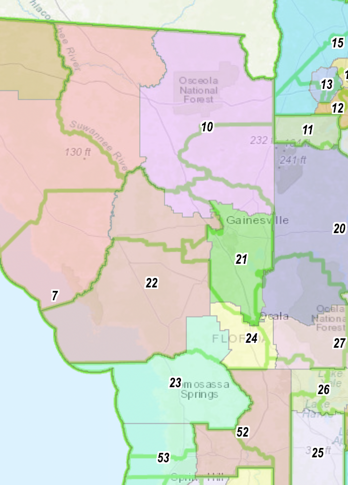
The expansion of HD 7 created the first big ripple effect that caused significant disruption on the new House map. HD 10 loses about half its geography on its east side and picks that up by absorbing Union and Bradford counties and much of north Alachua. Rep. Chuck Brannan, a MacClenny Republican, still lives within the lines. Meanwhile, the existing HD 21 gets carved up between Shoaf’s HD 7 and proposed HD 22 to the south. This brings some consequence by placing Republican Reps. Chuck Clemons and Joe Harding in the same zone by lumping Gilchrist and Levy counties together. Meanwhile, a more compact HD 21 spans the Alachua-Marion county line, making a district more analogous to the outgoing HD 20. The new district runs from Gainesville into Ocala. Citrus County becomes wholly part of the proposed HD 23, which also grabs parts of Marion around the county airport and the United Spanish Memorial Highway. Marion gets carved up significantly, with south Ocala ending up in HD 24, southeast Marion landing in HD 27 with rural east Lake County, and the Fort McCoy area settling into HD 20 spanning across the Putnam County line.
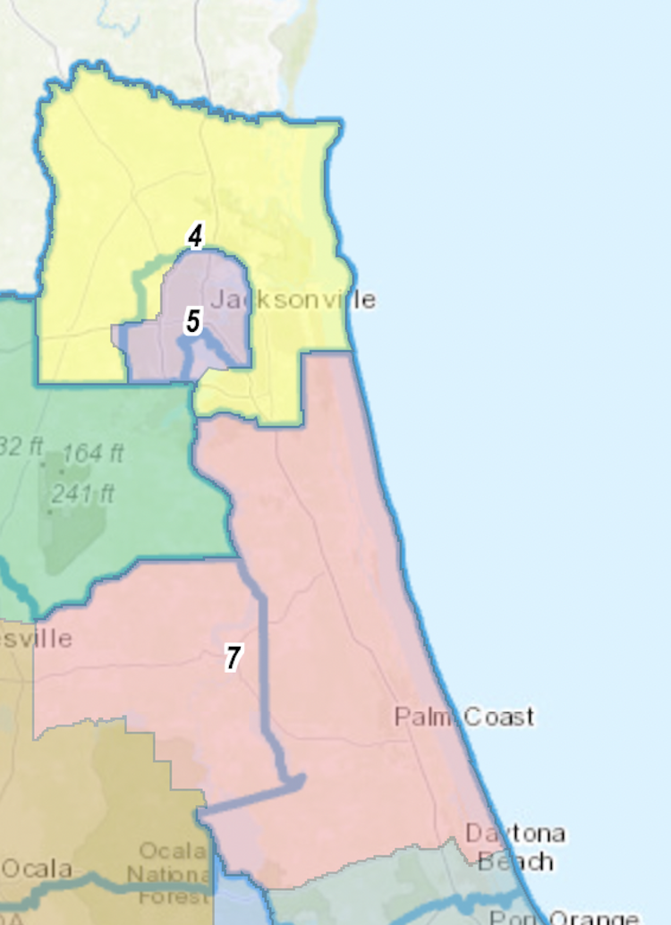
Northeast meets the sea: The configuration of Jacksonville with a Nassau County-focused district largely surrounding a minority access seat in the city core remains, though there’s new numbering coming to town. Proposed SD 5, which outgoing Sen. Audrey Gibson has dissed as a “duck on the river,” ends up with most of her urban jurisdiction but now goes right up to the St. Johns River shore. Land east of Interstate 295 like Bulls Bay Preserve now lands in proposed SD 4, which circles around SD 5 to the Atlantic coast and the Duval-St. Johns county line. SD 7 contains most of its current territory but stops on the south end at State Road 40. Meanwhile, all of Putnam now ends up in the coastal district.
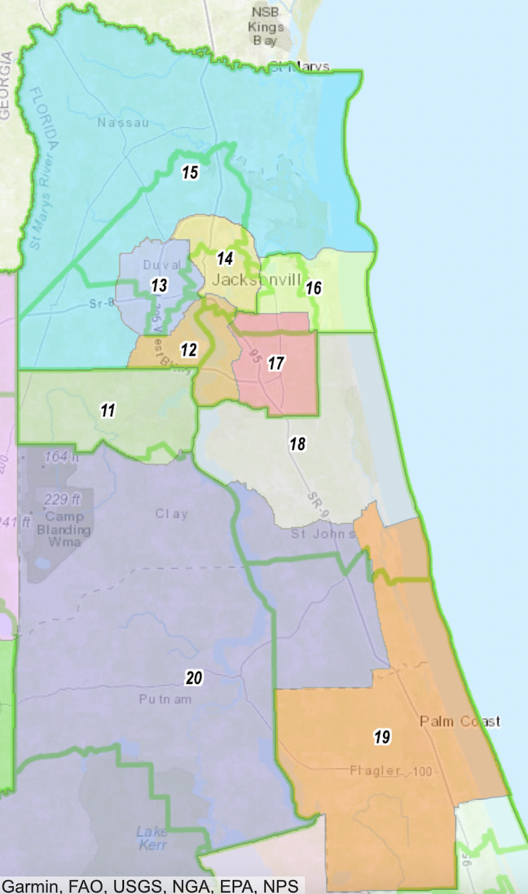
On the House side, the Nassau-encompassing HD 15 (analogous to the existing HD 11) reaches deeper geographically into Duval County. The House districts that previously reached the Nassau line now condense, with I-295 serving as HD 14’s northern boundary, while Pritchard Road currently serves as the divide between HD 15 and HD 13 in west Jacksonville. HD 14 now runs much further south, including almost all of the current HD 13. Meanwhile, everything north of Beach Boulevard from Southside Boulevard to the coastlands is in the new HD 16. Proposed HD 12 keeps areas around Naval Air Station Jacksonville in a district that now cuts off on the west at Old Middleburg Road. The old HD 18 becomes the new HD 11 on the map, picking up just a smidgen of land north of Peter’s Creek. HD 20 becomes the Putnam County district and bleeds into Marion as well. Meanwhile, Flagler County lands in HD 19.
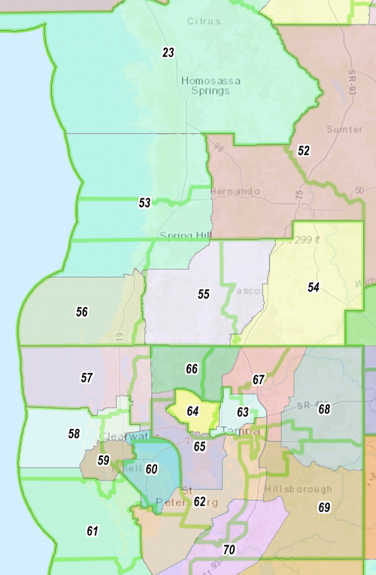
Tampa Bay: Some of the greatest geographic controversies this year involved the new lines in Tampa Bay, which in two cases pit incumbents from different parties against one another in newly drawn seats. The most controversial district in Florida, based on House debate, straddles Tampa Bay to form a new HD 62 with parts of south St. Petersburg and downtown Tampa, a re-imagining of a Black minority access seat that now cuts into four counties but can be navigated by car. The Pinellas portion differs little. But in Hillsborough, the district now covers Big Bend Road to the Selmon Expressway. The new HD 66 combines parts of districts now represented by Republican Traci Koster and Democrat Fentrice Driskell. The result is a jurisdiction covering northwest Hillsborough County west of I-275. The old House District 62 becomes the new House District 64, with Florida Avenue now providing an east edge. The new HD 63 has most of the old HD 61 north of Interstate 4 and another territory east of 52nd street to Interstate 75 south of Fowler. Brandon gets split four ways on this map, with everything northeast of Parsons Avenue and Lumsden Road landing in Plant City-centric HD 68, but everything northwest of State Road 60 and Parsons falls in HD 67, which stretches to the Pasco County line. The rest goes to HD 69, which spans east to the Polk County line and south to Manatee County, grabbing the homes of Democratic Rep. Andrew Learned and Republican Rep. Mike Beltran.
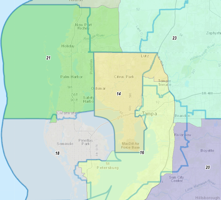
In Pinellas County, the old HD 68 becomes the new HD 60, trading a small piece of land south of Ulmerton with territory west of U.S. 19. That piece goes to neighboring HD 59. HD 59 covers Largo and much of Pinellas from Haines Bayshore Park west to the Gulf. But Pinellas south of State Road 694 falls chiefly now in HD 61, which is bound on the east by a CSX rail line and U.S. 19. Clearwater falls in HD 58, which runs north until Dunedin. Palm Harbor-centered HD 57 is now held entirely in Pinellas County, including everything above Curlew Road as well as north Dunedin and Safety Harbor. In Pasco County, everything west of Little Road lands in HD 56. HD 55 snatches Little to I-75, and the far east ends up in HD 54. East Hernando gets lumped in with Sumter County and The Villages in HD 52. As for the Senate map, there’s far less change from the benchmark lines. The minority access SD 16 largely represents a slightly more compact version of today’s SD 19. The Citrus Park-centered SD 14 reaches for communities east of I-275 but west of State Road 93-A. SD 18 swaps part of Belleair into SD 21 and receives south Clearwater in return. Much of east Hillsborough remains in SD 23, a replacement for SD 20. But the district reaches further north to cover all of Pasco east of State Road 589. A new SD 21, analogous to the current SD 16, grows eastward to grab more of Pasco south of State Road 52.
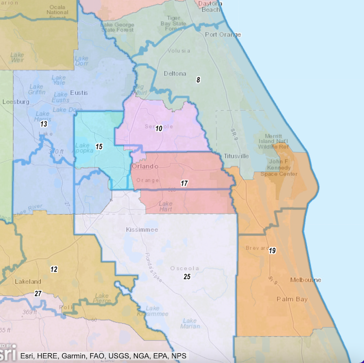
Happiest place on earth? Further up the I-4 Corridor, massive Central Florida growth means more legislative districts get packed into the Greater Orlando area. The proposed SD 12 covers Polk County north of the Polk Parkway or State Road 60. Lake County, Sen. Baxley’s soon-to-be home county, now makes up the bulk of the new SD 13 while grabbing the Walt Disney World area to get enough population for a district. The old SD 15 becomes the new SD 25, which gives up Disney land and most of its Orange County territory from the Orlando International Airport on the east. Meanwhile, SD 17, analogous to the current SD 13, expands to include the land SD 25 gives up. Similarly, a Seminole County-based SD 10 becomes more compact and cuts off at the Volusia County line. A minority district in downtown Orlando stays largely the same sans some land south of the Florida Turnpike. On the Space Coast, districts all scoot north, with SD 8 now spanning from State Road 40 in Daytona Beach south to NASA Parkway, and SD 19 then traveling south to the Brevard-Indian River county line.
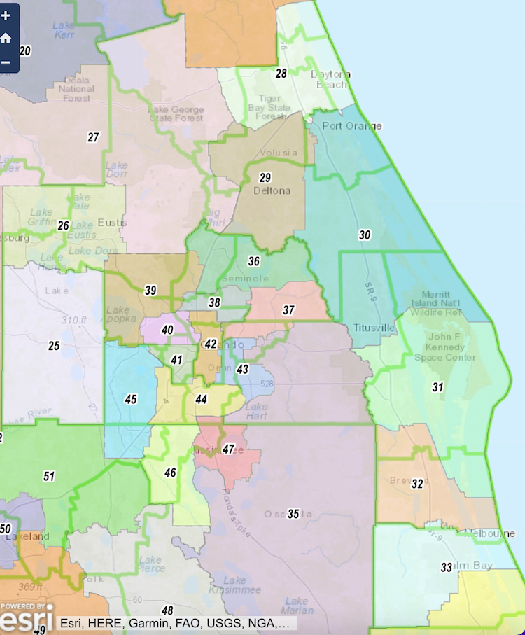
As far as House districts, Lake County from Leesburg to the Golden Triangle now falls in the new HD 26, while everything from Yalaha south goes in a South Lake-based HD 25. In Polk County, Lakeland proper all ends up in HD 50, with the rest of north Polk in HD 51. Winter Haven and the rest of southeast Polk east of U.S. 27 all go in HD 48. Bartow, Fort Meade and southwest Polk end up in HD 49. On the coast, Ormond Beach and Daytona Beach fill in HD 28, while the area from Port Orange to Merritt Island goes to HD 30. Inland Deltona and Deland make up most of HD 29. The Kennedy Space Center launches its rockets from HD 31, but from Rockledge to Melbourne, residents live in HD 32. Palm Bay falls in HD 33.
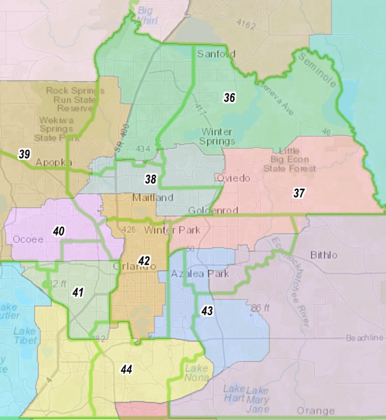
Orlando in the House: Apopka and Zellwood end up in northwest Orange County’s HD 39, with Ocoee the big community in HD 40. From south of the Turnpike to the Osceola-Polk border, voters cast ballots in HD 45, but Osceola County between Celebration and most of Kissimmee counts as HD 46. East Kissimmee and St. Cloud form up a new HD 47, while the rest of rural Osceola gets lumped in HD 35 along with the eastern outskirts of Orange County. Altamonte and Casselberry fill in HD 38, and the UCF community joins with Oviedo in Seminole County to make up HD 37. Northeast Seminole County, including Lake Mary and Sanford, is part of the new HD 36. Most of Orlando proper, at least east of Formosa Avenue, belongs to HD 42. The portions southwest of State Road 50 and I-4 end up in neighboring HD 41.
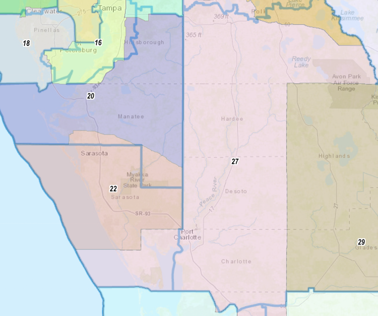
Manasota: The Senate lines changed little in the Sarasota-Bradenton area. Proposed SD 20, analogous to existing SD 21, saw small changes on its north end, picking up more of Riverview but dropping claim to Apollo Beach and Ruskin. Meanwhile, SD 22 to the immediate south now lurches north into Manatee up to State Road 70. It keeps all of Sarasota County but sheds any part of Charlotte County shared on the current map. The most significant change in the region is in SD 27. The existing Heartland-spanner SD 26 becomes a genuine Southwest Florida seat, now SD 27, by taking in all of Charlotte County and dropping off any Highlands, Glades or Okeechobee.
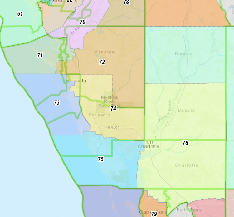
There are some significant shifts in House lines, however. A vacant HD 70 district now runs from Apollo Beach in Tampa Bay south to the Manatee River, putting Port Manatee in that jurisdiction. HD 71 becomes a Manatee County only seat, shedding Sarasota portions but taking in parts of a minority access seat that once stretched to St. Petersburg. An east Manatee County seat also drops any connection to Sarasota and current Rep. Tommy Gregory, a Sarasota Republican. Incidentally, Gregory ends up in a Sarasota County east-of-Interstate-75 district that runs south to include pieces of Venice and North Port before reaching the Charlotte line. Meanwhile, the new HD 73 largely seizes the coast from south Longboat Key to southern Venice, putting Gregory in a district with Rep. James Buchanan, a Venice Republican. While Charlotte today has just one House district, it now gets two Representatives, with HD 75 also covering the area where Englewood spills into Sarasota County. HD 76 largely puts everything south of Peace River with a more rural district that includes all of DeSoto County, but it also spills southward to grab North Fort Myers in Lee County.

Fort Myers-Naples Cape Coral has grown a little too large to get an entire House district to itself, but almost all of it goes into HD 79, excluding a piece northeast of Kismet Parkway and Juanita Place. HD 78 remains a Fort Myers district but a much geographically smaller one bound on the east by the Fort Myers city limits and going as far south as Lexington Country Club. The inland communities of San Carlos Park and Lehigh Acres land on a new HD 77 that hugs the Lee County line with neighboring counties to the east and south. An island-focused district remains, now numbered HD 80, that resembles the existing HD 76 except that it mostly cuts off on the south end at Immokalee Road. The rest of coastal Collier falls in a much more compact HD 81 but goes further than Marco Island, and you end up in the chiefly inland HD 82, which consumes the rest of Collier County and no more.
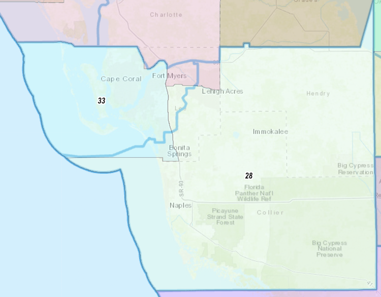
Lee County on the Senate side still mainly falls into one district, SD 33, but that seat’s far east end contracts to I-75 thanks to population growth in waterfront communities. It also now runs to the Collier County line. A portion of east Lee lands in the new SD 27, but everything south of Lee Boulevard goes with the geographically massive SD 28, including all of Collier and Hendry counties.
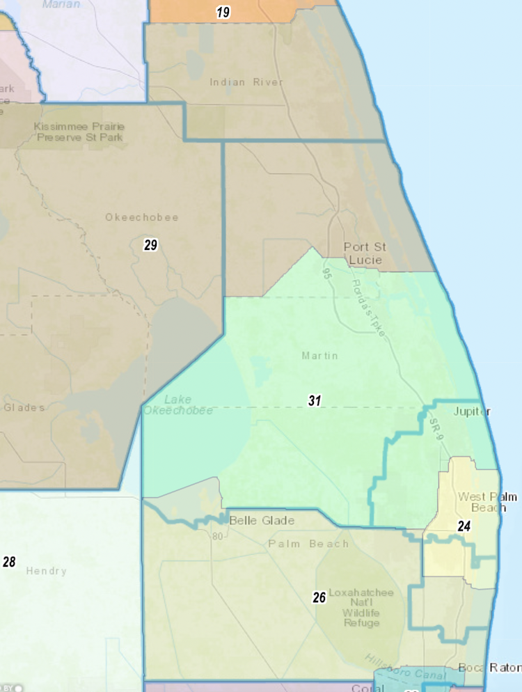
Gold Coast: The east side of the Florida Heartland connects with Indian River County and most of St. Lucie in the new SD 29. But south of the intersection of Glades Cutoff and Canal roads, the turf becomes part of the Atlantic coast’s SD 31. That district covers all of Martin County and most of Palm Beach County north of the West Palm Beach Canal.
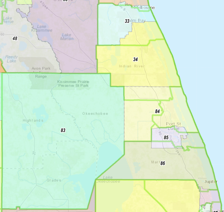
On the House side, HD 34 consists mainly of Indian River County, but it reaches north past Grant in Brevard County. Meanwhile, most of St. Lucie County falls in HD 84, though Port St. Lucie itself lies in House District 85, which reaches south across the Martin County line to Martin Highway. All of Highlands, Okeechobee, Glades and Hardee fall in HD 83. The existing HD 82 largely stays intact beside losing that slice and will be numbered as HD 86 on the new maps.
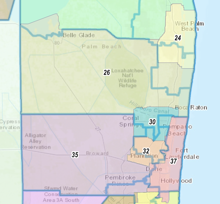
South Florida bound: The greatest concentration on population remains in three South Florida counties. But because those counties aren’t growing at the same rate as the rest of Florida, redistricting proved consequential as the region lost a House and Senate seat. Starting in Palm Beach and Broward, there are shifts already producing consequences. West Palm Beach east of the Turnpike remains in what’s now SD 24, which runs from State Road 786 in the north to Hypoluxo Road in the south. Then south of that, SD 26 begins and covers Boynton Beach, running south until Boca Raton. Glades Road largely serves as the border between SD 26 and SD 30. The latter district is where Democratic Sen. Tina Polsky already announced she plans to run, thus avoiding a primary with ally Sen. Lori Berman. Meanwhile, the Plantation area has been lumped in with a minority access seat in SD 32, which now has its north border around Tamarac and stretches south to State Road 93. Democratic Leader Lauren Book will move to SD 35, which covers Weston and reaches to cover all of east Broward. Meanwhile, the loss of a Senate district can largely be explained by combining parts of the old SD 34 and 38. On the new map, proposed SB 37 covers ground from Deerfield Beach in Broward County south to Sunny Isles Beach in Miami-Dade County, including the residences of Democratic Sens. Gary Farmer and Jason Pizzo along the way.
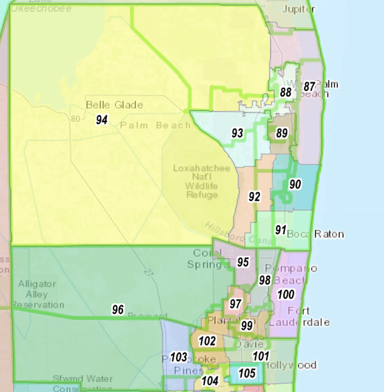
In the House, an inland HD 94 will now reach north Palm Beach County to the Turnpike, consuming much of the old HD 85. Meanwhile, Palm Beach Gardens now becomes part of the coastal HD 87 that also covers Palm Beach and as far south as Lantana, taking in most of the existing HD 89. Boynton Beach and Delray Beach now join in HD 90, while Palm Springs and Lake Worth Beach make up HD 89. Minority communities from Royal Palm Beach to Lake Park largely end up in HD 88. Meanwhile, inland Wellington fills HD 93, while communities around the Turnpike in south Palm Beach County largely land in HD 92. In Broward County, the coast from Lighthouse Point to Fort Lauderdale still ends up together in HD 100. But the Coconut Creek-centric HD 98 now pulls in much of Oakland Park. Another House district shifts south and keeps Wilton Manors and Plantation in the same jurisdiction. Parkland and Margate remain in HD 95, while west Broward now bears a new number in HD 96. A Weston district ends up inland at the Broward-Miami-Dade county line.
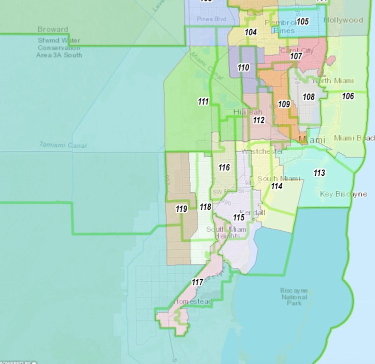
Miami sunshine: The handling of House districts in the Miami Gardens area ended up a source of heated debate. The area of Miami Gardens, Miramar, and Hollywood end up largely split in quarters, with Haitian Creole speakers now concentrated in HD 105 and HD 107. Most of North Miami remains intact in HD 108. Much of coastal Miami-Dade ends up the in Atlantic waterfront HD 106 that runs from Aventura down to Miami Beach. Coral Gables splits between HD 113 and HD 114. West of the waves, HD 109 is now the north fork of the Miami River as a southern boundary, and the Hialeah-centric HD 112 now reaches the Palmetto Expressway. A minority seat stretching from Cutler Bay south to Florida City becomes more slender than ever and largely grips to the east side of the Dixie Highway. South Miami ends up in HD 114, Pinecrest in HD 115, and Sweetwater in HD 116. Two dense and vertically aligned districts fill out the greater Miami area, with HD 119 bound by State Roads 997 and 825, and HD 118 filling in from there to State Road 821. Everything south of that urban cluster of seats combines with Monroe County in HD 120.
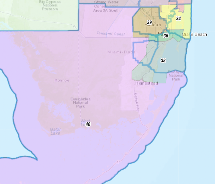
Beside the Broward-to-Miami Dade SD 37, five more Senate districts cover ground in Miami-Dade County. The heavily Hispanic Hialeah community lands in SD 39, which extends north to the county line and west to SR 997 and essentially keeps the existing SD 36 intact while also reaching south to the Tamiami Trail. But the swingy SD 37 and SD 40 are reshaped and renumbered as Democratic-leaning coastal districts. That results in the new SD 36 — an east-west oriented district stretching from Sweetwater to downtown Miami and also encompassing south Miami Beach and any islands in between — and the more southern SD 38 — which covers coastline south of Bird Road south to the Homestead Air Force Base and encompasses South Miami, Pinecrest, Palmetto Bay and Cutler Bay along the way. The expansive and rural inland Miami-Dade County, including much of Everglades National Park, combines with Monroe County and now established SD 40 as the Senate map’s southernmost point.