
Hurricane Idalia has reached Category 2 strength and is expected to hit Florida’s Gulf Coast, according to the National Hurricane Center. Florida Politics will monitor the storm. All times EST.
Florida Politics is monitoring closures related to the storm here.
2 p.m., Wednesday, Aug. 30
Idalia is still a hurricane, but just barely. A National Hurricane Center update put maximum sustained winds for the storm at 75 miles per hour, just barely enough to qualify as a Category 1 storm. But even if the next advisory pegs it as a tropical system, it continues to bring severe rain and wind through Georgia.
The center of the storm now sits 10 miles north-northwest of Waycross, Georgia hours after making landfall in Keaton Beach in the Florida Big Bend.
A hurricane warning has now been discontinued in Florida west of the Ochlockonee River, and has been downgraded to a tropical storm warning between the Suwanne to Ochlockonee rivers. The only hurricane warnings still in effect are on the coasts for Georgia and South Carolina.
But a storm surge warning remains from the Aucilla River south to Englewood on Florida’s Gulf Coast. Tropical storm warnings now stand in Florida south to Bonita Beach on the Gulf Coast and from the Volusia-Brevard county line north into Georgia.
12 noon, Wednesday, Aug. 30
The latest advisory from the National Hurricane Center indicated the center of Hurricane Idalia has moved beyond Florida, but threats of storm surge and tropical storm winds remain. Maximum sustained winds in the storm have lessened to 85 mph, a medium-strength Category 1 storm.
The center of the system is now 25 miles east-northeast of Valdosta, and is moving toward Savannah, Georgia 135 miles away. The storm is moving at 20 miles per hour. Current forecasts suggest the center of the storm will remain over land as it continues into South Carolina, and that it will then head out to sea near the North Carolina state line as a tropical storm.
11 a.m., Wednesday, Aug. 30
Hurricane Idalia continues a course through Florida’s Big Bend. While wind speeds have diminished significantly, the storm is still delivering 90 mph winds and remains a strong Category 1 storm. The eye is nearing the Georgia line, with the storm now about 15 miles south-southeast of Valdosta. The system is moving at about 20 mph with a minimum central pressure of 971 MB.
Storm surge warnings have been discontinued west of the Aucilla River. A hurricane warning has been downgraded to a tropical storm warning from the Suwannee River south to Longboat Key. Meanwhile, the threat of tropical storm winds west of Indian Pass has passed.
But storm surge warnings remain in place everywhere on the Gulf Coast from Englewood north to the Aucilla River.
In Keaton Beach, where Idalia made landfall this morning, the National Hurricane Center warns there could still be storm surge as high as 11 feet. In the metropolitan area around Tampa Bay, surge could still reach five feet.
10:20, Wednesday, Aug. 30
News4Jax has video of street sign-level flooding in Steinhatchee. That’s in the Big Bend region, where Hurricane Idalia made landfall this morning at Keaton Beach. But video is also surfacing online of downtown areas flooding as far south as St. Petersburg and Sarasota.
Meanwhile, utility companies report 268,280 people are currently without power, primarily in the Big Bend region.
10 a.m., Wednesday, Aug. 30
NOAA radar indicated Hurricane Idalia’s win speeds remain around 105 mph, with the storm located just 5 miles east-northeast of Madison as of 10 a.m. The storm is moving in a north-northeast direction toward Valdosta Georgia at around 18 miles per hour.
9 a.m., Wednesday, Aug. 30
The sustained wind force for Hurricane Idalia has reduced to 110 mph, making the storm a strong Category 2 storm hours after it briefly reached Category 4 status. But catastrophic storm surge continues in much of the Big Bend and beyond.
Perry Airport reports gusts of 62 mph.
An NOAA station in Cedar Key says tides have now risen to 6.8 feet above high tide.
The eye of the storm is now 20 miles south-southwest of Madison. The system is moving north-northeast, toward Valdosta, Georgia, at 18 mph.
8 a.m., Wednesday, Aug. 30
The eye of the storm, now 10 miles south-southeast of Perry, has started to move inland. The storm system, according to the latest National Hurricane Center advisory, now has sustained winds measuring 120 miles per hour. The system is projected to move at 18 miles per hour in a north-northeast direction. Central minimum pressure is now 950 mb.
A hurricane warning extends now from Altamaha Sound in Georgia to Edisto Beach in South Carolina, in addition to the remaining warning in Florida from Indian Pass in the Panhandle south to Longboat Key in Southwest Florida. Communities all along Florida’s Gulf Coast report high water. The City of Sarasota has closed the John Ringling Bridge and the Siesta Key Bridge.
7:45 a.m., Wednesday, Aug. 30
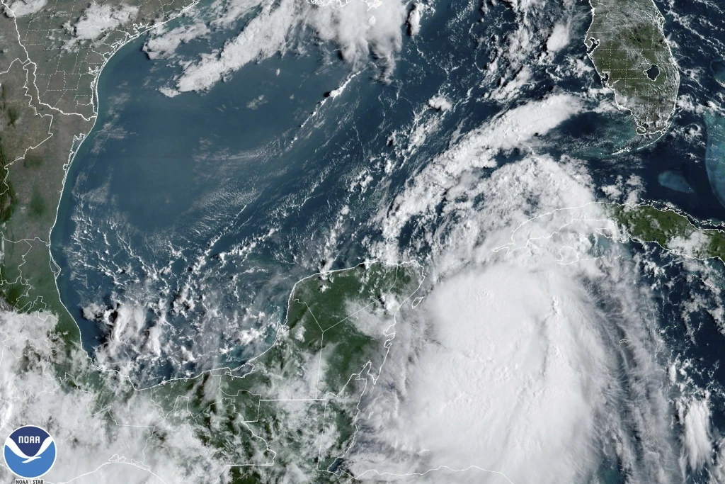
The National Hurricane Center reports Hurricane Idalia made landfall near Keaton Beach around 7:45 a.m. as a Category 3 storm.
That means satellite imagery shows the eye of the storm crossing onto land. The Air Force Reserve’s Hurricane Hunter planes report maximum sustained winds of 125 miles per hour as the hurricane makes its way through the Big Bend region. The latest minimum pressure for the storm is 949 mb.
Water levels around Cedar Key are rising rapidly and are already about 6 feet higher than the mean high water mark.
7:30 a.m., Wednesday, Aug. 30
The Weather Channel reports flooding along much of West Florida as far south as Crystal River, but with the worst of it occurring in Cedar Key and Horseshoe Beach.
Meanwhile, First Coast News had video of winds arriving on the shores of Cedar Key hours ahead of an expected landfall. Hurricane-force winds now extend 25 miles from the storm center but tropical storm-force winds have been reported 175 miles out.
7 a.m., Wednesday, Aug. 30
Catastrophic winds and storm surge have started to blast the Big Bend region in Florida. The land mass has started to impact the storm, but the National Hurricane Center still reports sustained winds of 125 miles per hour, reducing it to a Category 3 storm. But the center said the diminishing of wind speed does not reduce the threat of danger.
“Within the past hour, a C-MAN station on Cedar Key measured sustained winds of 47 mph (76 km/h), with a gust to 55 mph (88 km/h), and a Weatherflow station at Apalachee Bay measured a sustained wind of 43 mph (69 km/h), with a gust to 55 mph (88 km/h). A Florida Coastal Monitoring Program tower near Lake City, Florida, recently reported a wind gust to 51 mph (82 km/h).”
A National Oceanic and Atmospheric Administration station in Cedar Key also has measured tides at 5.2 feet above mean high water. Forecasts show some areas in the Big Bend could see storm surge as high as 16 feet.
The storm center is now 55 miles northwest of Cedar Key and 65 miles southeast of Tallahassee.
6 a.m., Wednesday, Aug. 30
Hurricane Idalia has grown to a Category 4 storm as it prepares to make landfall near Cedar Key.
A 6 a.m. advisory from the National Hurricane Center reports maximum sustained winds of nearly 130 mph. The center of the storm is located 60 miles west of Cedar Key and 90 miles south of Tallahassee. Its present movement is going 18 mph in a north-northeast direction, and it will make landfall within the next couple hours.
“After landfall, Idalia is forecast to turn toward the northeast and east-northeast, moving near or along the coasts of Georgia, South Carolina, and North Carolina late today and Thursday,” the advisory reads.
A storm surge warning still reaches as far south as Englewood and as far west as Indian Pass.
“While Idalia should weaken after landfall, it is likely to still be a hurricane while moving across southern Georgia, and near the coast of Georgia or southern South Carolina late today. Idalia should emerge off the southeastern United States coast early on Thursday and move eastward through late week,” the advisory reads.
11 p.m., Tuesday, Aug. 29
Wind speeds have reached 110 miles per hour in spots of Hurricane Idalia, according to an evening advisory from the National Hurricane Center. That puts it near the top intensity levels for a Category 2 storm, and forecasters expect very soon it will gain strength to become a major Category 3 hurricane.
The storm as of 11 p.m. sat due west of Tampa Bay around 125 miles out, and it sits 185 miles south of Tallahassee. It’s covering ground faster, moving at 18 miles an hour toward the coast and largely continuing a northward path. Most models show the storm shifting north-northeast as it approaches landfall.
While storm warnings and watches have been discontinued for the Florida Keys, threats are growing by the hour for North Florida, with storms expecting a rapid intensification overnight. A hurricane warning remains in effect from mid-Longboat Key to Indian Pass, an area under such a threat now consistently for two days. Storm surge warnings remain in effect as far south as Bonita Beach, covering Charlotte Harbor.
8 p.m., Tuesday, Aug. 29
The National Hurricane Center reports maximum sustained winds for Hurricane Idalia now at 105 mph. The storm now sits 155 miles west-southwest of Tampa Bay and 245 miles south of Tallahassee, with a northern trajectory of about 16 miles per hour.
Wind speeds are now being tracked by Hurricane Hunter aircraft.
“Additional strengthening is forecast, and Idalia is expected to become a major hurricane tonight before it reaches the Big Bend coast of Florida. Idalia is likely to still be a hurricane while moving across southern Georgia, and possibly when it reaches the coast of Georgia or southern South Carolina on Wednesday,” the latest advisory reads.
The storm produced 4 to 7 inches of rain in Western Cuba, and the storm is expected to deliver 12 inches of rain to portions of North Florida when it makes landfall Wednesday morning.
A tornado formed on Marco Island briefly earlier Tuesday but threats have largely moved past Southwest Florida. However, tremendous storm surge is expected along the Gulf Coast.
5 p.m., Tuesday, Aug. 29
Hurricane Idalia continues to gain strength in the Gulf of Mexico, where it has now become a Category 2 storm. The latest public advisory from the National Hurricane Center reports maximum sustained winds of about 100 mph, upgrading its classification.
The storm is now located 115 miles southwest of Tampa Bay, moving at about 16 miles per hour north toward the Big Bend. That’s a slight increase in speed and a significant jump in wind power.
Forecast storm paths from the National Hurricane Center (NHC) anticipate the storm making landfall around 8 a.m. on Wednesday morning as a Category 3 storm or stronger, meaning it will have 120 mph sustained winds or stronger.
A hurricane warning was expanded now to include from the mouth of the St. Mary’s River northward to Edisto Beach, South Carolina, while storm surge warnings are in place on the Atlantic coast now from Beaufort Inlet to Drum Inlet in North Carolina.
Bands of severe weather have started to affect South Florida communities, with NBC-2 reporting gusty winds and downpours in Cape Coral. A tornado warning has been lifted in Collier County. A storm surge warning issued south of Bonita Beach has also been lifted.
Gov. Ron DeSantis has expanded a state of emergency now to 49 of Florida’s 67 counties.
“A northward to north-northeastward motion is expected through tonight, with Idalia’s center forecast to reach the Big Bend coast of Florida on Wednesday morning,” forecasters write in the advisory. “After landfall, the center of Idalia is forecast to turn toward the northeast and east, moving near or along the coasts of Georgia, South Carolina and North Carolina late Wednesday and Thursday.”
2 p.m., Tuesday, Aug. 29
The latest advisory from the NHC shows little change in forecasts, with Hurricane Idalia still moving toward the Big Bend. The storm now sits 240 miles southwest of Tampa Bay and churns with maximum sustained winds of 90 mph.
That still makes it a Category 1 storm, but forecasters expect it to grow to at least a Category 3 storm, with 120 mph winds, and to make landfall around 8 a.m. on Wednesday. It has slightly picked up speed and moved north at around 15 miles per hour, still in a largely northern direction.
Wind will impact communities well before landfall, with hurricane-force gusts reported 15 miles out from the eye of the storm.
Storm surge remains a chief concern and the latest advisory raises flooding concerns. In the area from the Aucilla River to Yankeetown, the surge could reach as high as 15 feet. Between Yankeetown and Chassahowitzka and between the Aucilla and Ochlockonee rivers, forecasts predict 7 to 11 feet of storm surge.
In populous Tampa Bay, well to the south of expected landfall, forecasters are still advising residents to expect 4 to 7 feet of storm surge, and as far south as Englewood, a warning is in place with 3 to 5 feet of surge expected.
The new advisory brought no change in Florida to hurricane and tropical storm warnings, though threats have been lifted in other nations like Cuba with the storm danger there passed.
11 a.m., Tuesday, Aug. 29
Hurricane Idalia is spinning with maximum sustained winds of 85 mph. The Category 1 hurricane sits 120 miles west of the Dry Tortugas and 275 miles south-southwest of Tampa. National Hurricane Center forecasters warn the storm will bring life-threatening storm surge and hurricane conditions along Florida’s Gulf Coast.
The storm is expected to reach Category 3 status, with 120 mph winds, and is moving due north at 14 miles per hour. The central pressure for the storm is around 976 MB, forecasters report. There have been no changes in hurricane and storm surge warnings in Florida, but a tropical storm warning has now been issued Altamaha Sound, Georgia, north to South Santee River, South Carolina.
“A faster motion toward the north and north-northeast is expected through early Wednesday while Idalia approaches the Gulf coast of Florida,” an advisory from NHC reads. “A turn toward the northeast and east-northeast is forecast late Wednesday and Thursday, bringing the center of Idalia near or along the coasts of Georgia and the Carolinas.”
Hurricane-force winds now extend at least 15 miles outside the eye of the hurricane.
9 a.m., Tuesday, Aug. 29
A mandatory evacuation order has been issued in Dixie County, which lies directly in the forecast storm path for Hurricane Idalia. There are also Flood Zone A evacuation orders in place in Citrus and Pinellas counties. In Pasco County, both those in Zone A and any mobile homes or recreational vehicles have been ordered to evacuate.
In Gulf County, a mandatory evacuation has been ordered for recreational vehicles along C30 and Highway 98 from the Franklin County Line to Mexico Beach including all of Cape San Blas, Simmons Bayou, Indian Pass, Highland View and St Joe Beach.
In Lafayette County, a mandatory evacuation order applies to those living in low-lying and flood-prone areas or structures that have previously flooded during heavy rains. A similar order has been issued throughout Levy County.
A Suwannee County evacuation goes into effect at noon today for all low-lying and flood-prone areas. In Taylor County, all coastal residents and those in mobile homes, with trailers or in substandard housing have been put on a mandatory evacuation order.
Numerous voluntary orders have also been issued in coastal counties at risk. See more details at FloridaDisaster.org.
8 a.m., Tuesday, Aug. 29
Hurricane Idalia has intensified, with the National Hurricane Center reporting 80 mile-per-hour sustained winds as it barrels toward Florida.
Now located 320 miles south-southwest of Tampa Bay, the storm continues to move due north, but storm paths predict it will veer toward the Big Bend region. A hurricane warning remains in effect from mid-Longboat Key north to Indian Pass.
The storm is expected to grow to at least a Category 3 storm, with 120-mile-per-hour winds, today and to make landfall early on Wednesday, Aug. 30.
5 a.m., Tuesday, Aug. 29
As expected, Tropical Storm Idalia reached hurricane strength overnight. Forecasters at the National Hurricane Center warn the storm will become an “extremely dangerous major hurricane.” For now, the storm is a Category 1, with sustained wind speeds of 75 miles per hour.
The storm will churn and reach at least Category 3 status in the middle of the Gulf of Mexico, forecasts now show. While the storm has largely headed due north since it first started moving toward Cuba, forecasters have a wide portion of Florida’s Gulf Coast under hurricane warning, from central Longboat Key north to Indian Pass. Storm surge warnings reach farther south to Englewood, and a tropical storm warning runs south to Chokoloskee and west to Mexico Beach.
Hurricane Idalia as of 5 a.m. this morning was around 337 miles south-southwest of Tampa Bay.
As it moves north, the storm has significantly picked up speed and now travels around 14 miles per hour. The central pressure for the storm measures about 981 MB.
Hurricane-force winds span 15 miles out from the eye of the storm.
11 p.m., Monday, Aug. 28
Tropical Storm Idalia continues to churn 10 miles northwest of Cuba, delivering high winds on the western tip of the island. Forecasters say the high-speed storm, with 70 mph maximum sustained winds, could escalate into hurricane status at any moment.
It becomes a Category 1 Storm when winds reach 74 mph.
For the moment, it continues to move northward, covering about eight miles every hour.
The National Hurricane Center in its latest advisory expanded a tropical storm warning for Florida’s east coast from Sebastian Inlet to Altamaha Sound in Georgia. The predicted path for the storm remains focused on Florida’s Gulf Coast. Forecasters anticipate the system will be a major hurricane when it makes landfall in Florida early Wednesday and will continue as a hurricane as it traverses the state.
8 p.m., Monday, Aug. 28
The forecast for Tropical Storm Idalia remains largely unchanged, with the system still expected to reach major hurricane status before Wednesday morning. The expected path for the storm, according to the National Hurricane Center, remains a course to the Big Bend, but an area from Indian Pass in the Panhandle south to the central Longboat Key remains under hurricane warning.
A storm surge warning spans as far south as Englewood.
The storm as of 8 p.m. on Monday evening was located 20 miles southwest of Cuba with maximum sustained winds of 70 mph. The system is now 250 miles southwest of the Dry Tortugas, moving northward at a steady rate of 8 mph.
5 p.m., Monday, Aug. 28
Tropical Storm Idalia has nearly reached hurricane-force strength, with maximum sustained winds of 70 miles per hour as it nears Cuba. The storm will be classified as a Category 1 hurricane when it reaches 74 mph.
The system sat about 35 miles south-southwest of western Cuba when the National Hurricane Center released its 5 p.m. advisory. Forecasts now show the storm becoming a major hurricane by early Wednesday morning and making landfall in the Big Bend at some point that morning.
Under the most recent advisory, NHC now has issued a hurricane warning from mid-Longboat Key north to Indian Pass, covering all of Tampa Bay. Tropical storm warnings span south of Longboat to Chokoloskee, and west of Indian Pass to Mexico Beach. There is also a tropical storm warning in the Dry Tortugas.
Forecasters have stressed the danger of storm surge in the entire hurricane warning area and south to Englewood.
On the Gulf Coast, there remains a tropical storm watch in the lower Florida KeYs west of the Seven Mile Bridge, and on the Atlantic coast from Sebastian Inlet not to South Santee River in South Carolina.
2 p.m., Monday, Aug. 28
For now, Idalia remains a tropical storm but wind speeds have already picked up to 70 miles per hour, and it’s still expected to reach hurricane strength later today.
The storm sits 50 miles south-southwest of Cuba, but continues to move north at a rate of 8 mph.
The National Hurricane Center hasn’t extended hurricane watches and warnings since its 11 a.m. advisory. A hurricane warning remains in effect from the middle of Longboat Key north to the Ochlockonee River, spanning much of west Florida including Tampa Bay. There are tropical storm warnings that extend south to Chokoloskee and west to Indian Pass.
Forecasters still warn that storm surge could be the greatest threat in many areas, even some with no hurricane or tropical storm warnings in place.
Tropical Storm Idalia could deliver as much as 11 feet of storm surge to those around the Chassahowitzka and Aucilla rivers, according to the latest advisory from the NationAL Hurricane Center.
12 p.m., Monday, Aug. 28
National Hurricane Center forecasters warn storm surge could impact areas far south of the storm track for Tropical Storm Idalia. Michael Brennan, acting deputy director of the NHC, in a livestream told residents on Florida’s west coast to prepare to evacuate at least tens of miles from the coast.
While Idalia remains a tropical storm with 65 mph winds, Brennan said it’s expected to be a major hurricane by the time it makes landfall in the Big Bend region. But the biggest concern the NHC is broadcasting right now involves the threat of flooding.
“The circulation of Idalia is going to push water from the Gulf of Mexico up into places like Charlotte Harbor, Tampa Bay and the Big Bend region,” he said.
He predicted four to six feet of storm surge in Tampa Bay. To the north near the Anclote and Chassahowitzka Rivers, he anticipates six to nine feet of surge.
11 a.m., Monday Aug. 28
The National Hurricane Center now has a hurricane watch in place from Englewood north to the middle of Longboat Key, and also from west of Ochlockonee River west to Indian Pass. That means forecasts predict hurricane-force winds to arrive in those locales within the next 48 hours.
A tropical storm watch, meanwhile, is now in effect for the lower Florida Keys west of the Seven Mile Bridge, and now from Sebastian Inlet north to Altamaha, Georgia.
A storm surge watch is also in effect from Chokoloskee northward to Englewood, including Charlotte Harbour, from the Ochlockonee River to Indian Pass, and from the mouth of the St. Mary’s River to Altamaha Sound in Georgia.
Those are the areas most at risk, but there’s also a hurricane warning in effect for the middle of Longboat Key northward to the Ochlockonee River, including Tampa Bay. There’s also a tropical storm warning in the Dry Tortugas and from Chokoloskee northward to central Longboat Key, and west of the Ochlockonee River to Indian Pass.
Idalia remains a tropical storm, and is now located 80 miles south-southwest of Cuba, and headed north at 8 miles per hour. The system itself has sustained winds of 65 miles per hour, but it is expected to intensify in the Gulf of Mexico to major hurricane-force winds.
9:50 a.m., Monday Aug. 28
Gov. Ron DeSantis has expanded an executive order to declare a state of emergency for most Florida counties.
Those covered now include: Alachua, Baker, Bay, Bradford, Calhoun, Charlotte, Citrus, Clay, Collier, Columbia, DeSoto, Dixie, Duval, Flagler, Franklin, Gadsden, Gilchrist, Gulf, Hamilton, Hardee, Hernando, Hillsborough, Lake, Jefferson, Lafayette, Lee, Leon, Levy, Liberty, Madison, Manatee, Marion, Pasco, Pinellas, Polk, Putnam, Nassau, Sarasota, Seminole, St. Johns, Sumter, Suwannee, Taylor, Union, Volusia, and Wakulla counties.
7 a.m., Monday, Aug. 28
Tropical Storm Idalia is moving slightly quicker in a northward direction at about 8 miles per hour. The maximum sustained winds remain around 65 miles per hour, but National Hurricane Center forecasters anticipate Idalia will reach hurricane strength as it approaches Western Cuba.
As of 7 a.m., the storm was located around 90 miles south of the island nation’s western tip.
4 a.m., Monday, Aug. 28
Tropical Storm Idalia will likely deliver life-threatening storm surge and winds to Florida, according to the National Hurricane Center. The current forecast trajectory predicts the storm will reach major hurricane strength before hitting Florida’s Gulf Coast early Wednesday.
Idalia could approach Florida on Wednesday with winds of up to 100 mph, which would make it a Category 2 storm at that time.
The storm as of 4 a.m. on Monday remained about 125 miles south of the Western tip of Cuba, according to a storm advisory. Forecasters said the storm was intensifying as it approached the island. The National Hurricane Center issued a hurricane warning for Pinar del Rio, Cuba.
Much of Florida’s west coast remains at risk of hurricane conditions in the coming days. The NHC issued a hurricane watch from Englewood north to Indian Pass Florida, covering all of Tampa Bay. A storm surge watch is also in effect from Chokoloskee to Indian Pass.
There’s now a tropical storm warning in effect for the Dry Tortugas in Florida, as well as for the Yucatan Peninsula in Mexico from Tulum to Rio Lagartos, including Cozumel, and for the Isle of Youth, Cuba. A tropical storm watch remains in effect from Englewood south to Chokoloskee, and in the lower Florida Keys west of the Seven Mile Bridge.
The storm as of Monday morning had maximum sustained winds of 65 miles an hour and remained a tropical storm. The system continues to move due north at 7 miles per hour.
But forecasts predict Idalia will reach hurricane-force wind strengths before it reaches Cuba, and that it will become a major hurricane in the Gulf of Mexico.
“On the forecast track, Idalia is forecast to increase in forward speed and turn north-northeastward over the eastern Gulf of Mexico on Tuesday and reach the Gulf coast of Florida on Wednesday,” the advisory predicts.
“Maximum sustained winds have increased to near 65 mph (100 km/h) with higher gusts. Idalia is forecast to become a hurricane later Monday and a dangerous major hurricane over northeastern Gulf of Mexico by early Wednesday.”
Meanwhile, Hurricane Franklin became the first storm of the season to reach major hurricane-force strength. But that Atlantic Ocean storm remains 505 miles southwest of Bermuda and is not anticipated to make landfall. Officials in Bermuda are encouraged to monitor the storm but forecast tracks show the storm heading northwest away from the United States.
11 comments
Michael K
August 28, 2023 at 9:07 am
Must be serious if the governor is pretending to be concerned.
I think we are about to re-learn the wisdom of “resign to run.”
Earl Pitts American
August 28, 2023 at 9:07 pm
Good evening America,
Survays just in from the trusted Earl Pitts American Fan Club Poly-Sci Bureau clearly show 96.647 % of Floridians are greatfull to have a man of integerity, honor, and experience at the helm as opposed to a Dook 4 Brains Crist, Fried, or Gillum in charge when things get real such as this Hurricane.
Thank you America,
Earl Pitts American
Earl Pitts is a Pedophile
August 30, 2023 at 10:39 am
Why haven’t you killed yourself yet, Earl?
Pedophile lives are worthless.
yodegi
August 30, 2023 at 12:41 am
that I got from this agency I discovered over the internet and they paid me for it
JulianaKevin
August 28, 2023 at 3:13 pm
I can’t believe I paid $19,000 for my first general test, according to a friend bs07 of my younger brother. Simply click the
.
.
Link to get started…………………………………richprofithome.blogspot.com
My Take
August 28, 2023 at 4:28 pm
Heaven is either warning or punishing redneck north Florida over DeSSatan.
Q told me.
Impeach Biden
August 30, 2023 at 7:15 am
I believe the storm is targeting Nikki Fried and her phony scientist friend Rebekah Jones. Don’t worry the rednecks can take care of themselves. The Demos always have their hands out and are incapable of of doing anything without government assistance. Will this be another “no comment” moment from the incompetent in Chief?
My Take
August 28, 2023 at 4:32 pm
As a kid, hurricanes used to be fun (unless the power went out and one sweltered).
Now, too worrisome.
Details
August 29, 2023 at 11:59 pm
All times EDT, actually. EST starts the first Sunday in November!
Dr. Franklin Waters
August 30, 2023 at 10:41 am
I wonder how many people the Governor killed with his idiotic and irresponsible “Resilient” mobile homes comment.
Between that and Covid his kill count must be among the top governors of all time.
Earl Pitts American
August 30, 2023 at 1:37 pm
Thank you Dr. FRANKENSTEIN,
It’s great to have a compedent conservatuve like The Next POTUS, Ron Desantis, America’s Favorate Govornor Ever in charge at a time like this. Floridians are truley blessed indeed!
Dr. Frank, why just try and imagine if we had a Gillum, Crist, or Fried in charge. It would be chaos and pandimonium rulling the day every day. And God forbid a Gillum, Crist, or Fried be in charge of distrubiting Hurricane Federal Relief moneys in Florida. They would squander the Federal dollars on self serving and disgusting woke agenda items such as cutting off little boys ₩einers and sewing in fake breastisis to try and make little girls out of them.
Granted Dr. Frankenstein that would be great for your medical practise because that’s what you do. But it would at the same time be something to be sent to #eII for Dr Frank. Think about where you want to spend eternity Dr. Frank.
Thank you Govornor Desantis,
EPA
Comments are closed.