

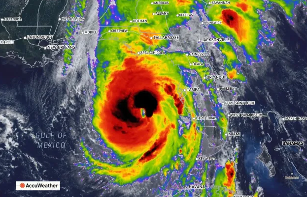
AccuWeather’s most recent forecast said the hardest-hit areas of Florida could see storm surges of two stories high when Hurricane Helene makes landfall as an expected Category 4 maelstrom.
Counties in the state’s Big Bend and Panhandle region — Bay, Dixie, Franklin, Gilchrist, Gulf, Jefferson, Lafayette, Leon, Levy, Liberty, Suwannee, Taylor, Union and Wakulla, Walton, Washington — will get it worst, with up to 23-foot-high flooding rendering areas “unsurvivable” for people there.
Bad flooding should stretch through Tampa Bay, where there could be 6-10 feet of inundation.
Maximum sustained wind speeds on the Saffir-Simpson Hurricane Wind Scale are likely to be between 131 and 155 mph.
As the storm nears, Waffle House confirmed to CNN that it preemptively closed locations in Florida, ticking off the dread-inducing box known as the Waffle House index, a former Federal Emergency Management Agency official cited as indicating a severe squall is imminent.

If the message isn’t clear yet, here it is: For those in the Big Bend especially, get out while you can.
“If authorities tell you to leave, please evacuate,” AccuWeather Chief Meteorologist Jon Porter said. “In the areas with the greatest risk of the water surge along and near the coast, you only have a matter of a few hours to potentially save your life – please leave safely as quickly as you can. Conditions will be extremely dangerous after dark.”
Porter added that Helene’s destructive winds will reach far inland, as will “a catastrophic flash flooding situation hundreds of miles away from the point of landfall.”
The Florida Keys, the northeast coast of the Florida Peninsula, will see storm surges of 1-3 feet. On the western end of the Panhandle, stretching east and south to the Everglades, there is likely to be a surge of 3-6 feet.
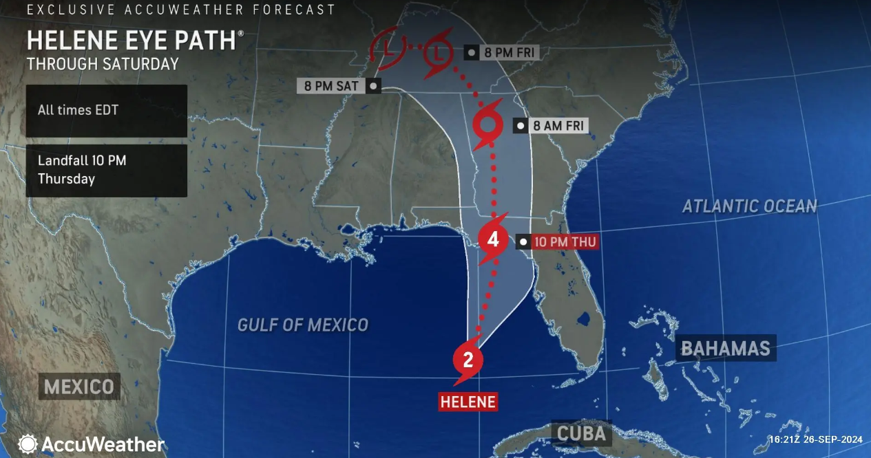
Dan DePodwin, Senior Director of Forecasting Operations at AccuWeather, said it’s “not fully out of the question” that Helene could strengthen to Category 5 strength — with maximum sustained winds of 156 mph or more — before striking the state.

The storm could also settle at a Category 3 if some factors don’t align, such as dry air intrusion. But the impact will nevertheless be “devastating.”
Chief Video Meteorologist Bernie Rayno said AccuWeather forecasts Helene to land between 10 and 11 p.m. in the Apalachicola area between Mexico Beach in Bay County and Horseshoe Beach in Dixie County.