


5 p.m. August 2
National forecasters say Tropical Storm Isaias has strengthened slightly while traveling just offshore of Central Florida’s east coast.
The storm is approximately 35 miles to the southeast of Cape Canaveral and producing maximum sustained winds of 70 mph.
The center of Isaias is forecasted to continue just off of Florida’s east coast through tonight before reaching the Carolinas late Monday into Tuesday.
Current models project Isaias to pass offshore of Georgia.

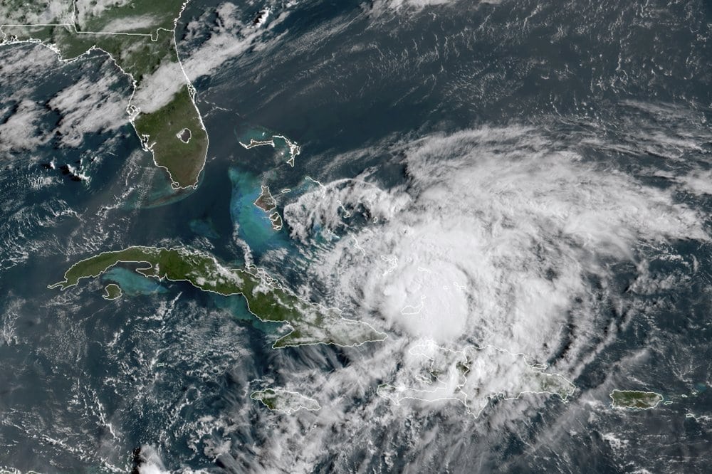
8 a.m. August 2
Throughout the night, wind shear has prevented the tropical storm from reorganizing and it now appears it will not intensify.
Tropical Storm Isaias has reached the waters off South Florida, centered about 40 miles east-southeast of West Palm Beach, with winds of 65 mph. It likely will remain at that intensity for the next 36 hours as it makes its way up the coast, skirting Florida between Sunday morning and about noon Monday.
A storm surge watch is now in effect from Jupiter Inlet to Ponte Vedra Beach. A tropical storm warning is in effect from Hallandale Beach Florida to South Santee River, South Carolina, and for Lake Okeechobee.
8 p.m. August 1

National forecasters say that while Isaias lowered in tropical storm strength, it will reorganize overnight into a hurricane as it approaches Florida.
The storm dropped to maximum sustained winds of 70 miles per hour Saturday evening but continues moving to U.S. shores at 9 miles per hour. warnings and watches remain in place in Florida. The storm is located about 85 miles southeast of Fort Lauderdale.
2 p.m. August 1
Hurricane Isaias has emerged over the straits of Florida and continues to approach the state at 12 miles per hour, the National Hurricane Center reports.
The Category 1 storm is now about 140 miles southeast of Fort Lauderdale, moving toward the area. Maximum sustained winds in the storm have gone down to about 75 miles per hour since it made landfall in islands around the Bahamas.
All previous warnings and watches remain in place.
11 a.m. August 1
The entire east coast of Florida now how some level of storm alert as Hurricane Isaias has made makes a slow approach toward the state. The hurricane has made landfall on Northern Andros Island and is now expected to approach Southeast Florida today and Sunday.
The Category 1 storm, sustained winds of up to 80 miles per hour, is about 135 miles south-southeast of Grand Bahama Island, the National Hurricane Center reports. The storm slowed but is still moving northwest toward Florida at around 12 miles per hour.
The area from Boca Raton to the Volusia-Flagler county line is now under a hurricane warning, while Boca Raton south to Hallandale Beach is under a hurricane watch.
A watch has been upgraded to a tropical storm warning from the Volusia-Flagler line to Ponte Vedra Beach, while a tropical storm watch has now been issued north of Ponte Vedra into Georgia.
8:00 p.m. July 31
The first winds associated with Hurricane Isaias could hit Florida early Saturday morning, according to the latest advisory from the National Hurricane Center. Hurricane conditions are expected along Florida’s eastern coast late Saturday and into the evening.
Forecasters say anyone still preparing their properties or taking measures to protect themselves should complete that task as soon as possible.
Storm surge could hit the coast between Jupiter and Sebastian Inlet, reaching as high as four feet above ground level. Low lying areas of east Central Florida could be subject to flash flooding and urban flooding.
Isaias remains a Category 1 hurricane with maximum winds up to 80 miles per hour.
5:00 p.m. July 31
Hurricane Isaias continues to move toward Florida at a speed of 15 miles per hour and has held close to a forecast stormpath. The National Hurricane Center now shows it could be 2 a.m. Sunday before the eye of the storm Southeast Florida.
Hurricane warnings have now been issued for much of Florida’s east coast, from Boca Raton to the Brevard-Volusia county line. A hurricane watch extends from there north to the Flagler county line, and south to Hallandale Beach. There’s a storm surge warning from Sebastian inlet to Jupiter. There’s also now a tropical storm warning for Lake Okeechobee.
3: 30 p.m. July 31
Gov. Ron DeSantis ordered a state of emergency for the following Florida counties that could be impacted by Hurricane Isaias: Brevard, Broward, Clay, Duval, Flagler, Indian River, Martin, Miami-Dade, Monroe, Nassau, Okeechobee, Orange, Osceola, Palm Beach, Putnam, Seminole, St. Johns, St. Lucie and Volusia.
2 p.m. July 31
Hurricane Isaias is becoming better organized, according to the National Hurricane Center.
The storm is now 245 miles southeast of Nassau. The three-day forecast shows the storm could hit Florida around 8 p.m. on Saturday.
11 a.m. July 31
South and Central Florida could face heavy rains as soon as Friday evening courtesy of a Category 1 hurricane now impacting the Caribbean.
The latest public advisory on Hurricane Isaias includes a hurricane watch for portions of Florida’s East Coast from north of Deerfield Beach to the Volusia-Broward county line. A watch has been upgraded to a tropical storm warning for Ocean Reef north to Sebastian Inlet, and for Lake Okeechobee.
But a tropical storm warning has been discontinued for the Dominican Republic.
A projected three-day stormpath shows the storm may make landfall in Florida around 8 p.m. Saturday.
8 a.m. July 31
A tropical storm watch remains in effect in Florida from Ocean Reef to Sebastian Inlet. National forecasters say more warnings could be issued in the United States today, and the projected storm path still includes much of Florida’s east coast.
Heavy rains could arrive in Florida as soon as Friday night.
Storm force winds and heavy squalls have arrived in the Bahamas, with hurricane conditions expected today, the latest National Hurricane Center advisory states. Hurricane Isaias has moved 30 miles northwest of Great Inagua Island.
There are now tropical storm warnings in place for all of the Dominican Republic’s coastal areas and the Turks and Caicos Islands.
5 a.m. July 31
The storm forecasts for Hurricane Isais show the storm hugging Florida’s East coast starting this weekend.
The three-day storm path shows the hurricane potentially making landfall in the U.S. before 2 a.m. Sunday, according to the National Hurricane Center.
Hurricane conditions were expected throughout the day Friday in the Bahamas, which braced for the storm. The hurricane has maximum sustained winds now of 80 miles per hour with some higher gusts, making it a Category 1 hurricane. Tropical-storm-force winds extend 205 miles from the center of the storm and hurricane-force winds reach 45 miles from its center.
A 5 a.m. advisory put the storm about 15 miles south-southwest of Great Inagua Island and 185 miles southeast of Nassau. It continues to move northwest at a speed of 17 miles per hour.
In Florida, a tropical storm watch is in effect from Ocean Reef to Sebastian Inlet, as well as along the shore of Lake Okeechobee.
A warning is typically issued 36 hours before anticipated tropical-storm-force winds reach an area. Tropical storm warnings have already been issued in the Dominican Republican, the northern shore of Haiti and in the Turks and Caicos Islands, while hurricane warnings are in effect in the northwestern, southeastern and central Bahamas.
Some decrease in speed is expected over the course of the next few days as Isaias moves toward Florida.
This post will be updated.
One comment
Sonja Fitch
August 2, 2020 at 10:42 am
Some of the stormy clouds are Duffus Desantis snd Nazi Rick fighting for tv coverage ! Lol ! Both of you are incompetent! Nazi Rick you left the unemployment mess in Florida! Now Nazi Rick you left DC and people with unemployment on the national level! Are you two delusional white privileged men going to wrestle for the accolades? Neither one of you are going to get accolades!
Comments are closed.