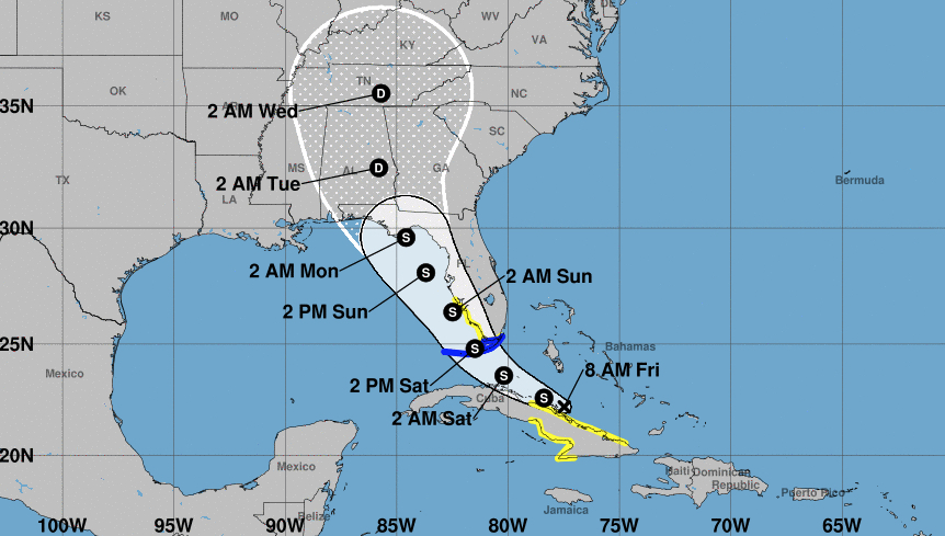
Tropical depression Fred was slowly strengthening and could regain tropical storm status sometime on Friday, ahead of its projected track towards the Florida Keys and southwest Florida, forecasters said.
The system was dropping heavy rain over parts of Cuba in the early morning hours and was expected to reach Florida by Saturday, the U.S. National Weather Service said.
The main threats were rain and flooding. A tropical storm warning was issued Friday morning for the Florida Keys and Florida Bay. A tropical storm watch was in place for southwest Florida and parts of Cuba.
The 8 a.m. Friday forecast from the National Hurricane Center projects Fred to cross the Florida Keys early Saturday afternoon and then track close to the Florida Gulf Coast through the rest of Saturday and all day Sunday, making landfall east of Apalachicola early Monday morning.
The hurricane center said 3 to 7 inches of rain were expected across the Florida Keys and southern peninsula by Monday, with isolated maximums of 10 inches (25 centimeters).
Once a tropical storm, Fred weakened back to a depression by its spin over Haiti and the Dominican Republic, where it knocked out power to some 400,000 customers and caused flooding that forced officials to shut down part of the country’s aqueduct system, interrupting water service for hundreds of thousands of people.
Local officials reported hundreds of people were evacuated and some buildings were damaged. There were no immediate reports of casualties.
Heavy rains on Thursday continued to pound Hispaniola, which the two nations share.
The Miami-based U.S. hurricane center said Fred had maximum sustained winds of 35 mph Friday morning and was centered just north of Cuba’s coast.
At 8 a.m. Friday, the system was about 370 miles east-southeast of Key West, Florida. That was also about 125 miles south-southwest of Great Exuma Island in the Bahamas.
Fred was headed west-northwest at 10 mph.
The system was expected to produce 3 to 5 inches of rain across the Dominican Republic and the western Bahamas, as well as 1 to 3 inches over Haiti, the Turks and Caicos, the eastern Bahamas, and Cuba.
Fred became the sixth named storm of the Atlantic hurricane season late Tuesday as it moved past the U.S. Virgin Islands and Puerto Rico.
____
Republished with permission from The Associated Press.


One comment
Andrew Finn
August 13, 2021 at 9:04 am
Not to worry — Emperor DeSantis will issue an edict banning Fred from coming near Florida.
Comments are closed.