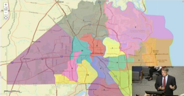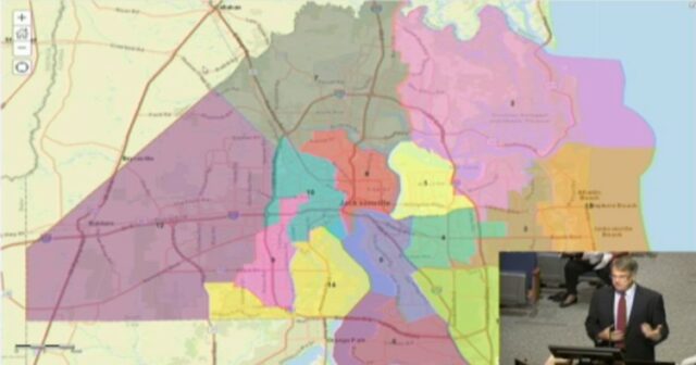
A Jacksonville City Council Special Committee continued its second try at redistricting, refining a map Thursday with an attempt to set up the full Council to consider it Friday morning.
But the discussion was heated at times and outstanding issues remain, even as the committee moved the redistricting plan forward.
Jacksonville passed a redistricting map earlier this year to be effective in next year’s elections, but a federal judge struck it down, citing a lack of compactness and an “unnecessary racial segregation” throughout areas North and West of the St. Johns River.
The appellate process continues, but the Council faces a hard Nov. 8 deadline for a “remedy” map, and committee passage is essential to keep that on track.
The Council could submit a map as late as Nov. 18, but per a city lawyer, the later submission would “let the judge do what she wants” with the revised product.
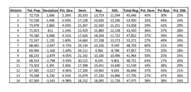
The committee proceeded Thursday from the so-called maroon map which created five districts with Democratic advantages, four of those with 50% or more Democrats, and one (District 14) split evenly between Democrats and Republicans in registration. The remaining nine districts would see Republican plurality advantages.
District 14 Republican Randy Defoor, who was not on the committee, was successful in compelling the panel to direct Redistricting consultant Douglas Johnson to come up with maps that would keep Riverside and Avondale together, as is currently the case. But she could not compel the committee to accept any of those maps.
Johnson provided three options for consideration. Option A placed Riverside, Avondale and Murray Hill in one district with Ortega and Fairfax, encompassing 25,000 residents total in a more northward-oriented District 14. Option B put Riverside and Avondale into 14, leaving Murray Hill in 9. This would move everything north of Collins into District 7, Johnson contended. The third option combined all three neighborhoods into District 9.
None of those plans appealed to the committee in the end. The “maroon” map was brought back, with the intention of revising it to put Riverside and Murray Hill together in a district. Defoor, leaving the Council next year, said she wanted more people from Argyle to make up the “numbers” in 14.
The new map also will include an ask from its sole Democrat, Ju’Coby Pittman, to ensure she is drawn into a favorable position in a district for re-election. That solution may include a flip of territory with the current Reggie Gaffney seat.
Co-Chair Aaron Bowman also was successful in ensuring the gated Queen’s Harbour community stayed intact in one district. A community outcry to keep San Mateo in District 2 also looks like it will make it into the final map, and a version will be drawn that keeps Riverside and Murray Hill together in a new District 10, with Avondale allocated to neighborhoods to the south, cleaving the Riverside/Avondale Historic District.
Council members will hear from the public Thursday evening, in a “map chat” town hall, offering citizens a say before Friday morning’s ratification of the replacement map. Any suggested amendments or proposals are due before that meeting.
Council President Terrance Freeman, who Chairs the committee, said the committee product is a “recommendation” and that Friday would allow for further revisions.
Pending revisions today, below is the current working map.


One comment
Kevin Wills
November 3, 2022 at 3:56 pm
The new map Now splits Historic Springfield at Pearl Street. All of Springfield needs to be one district and not split.
Comments are closed.