

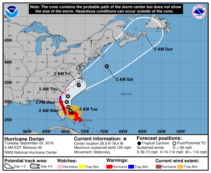
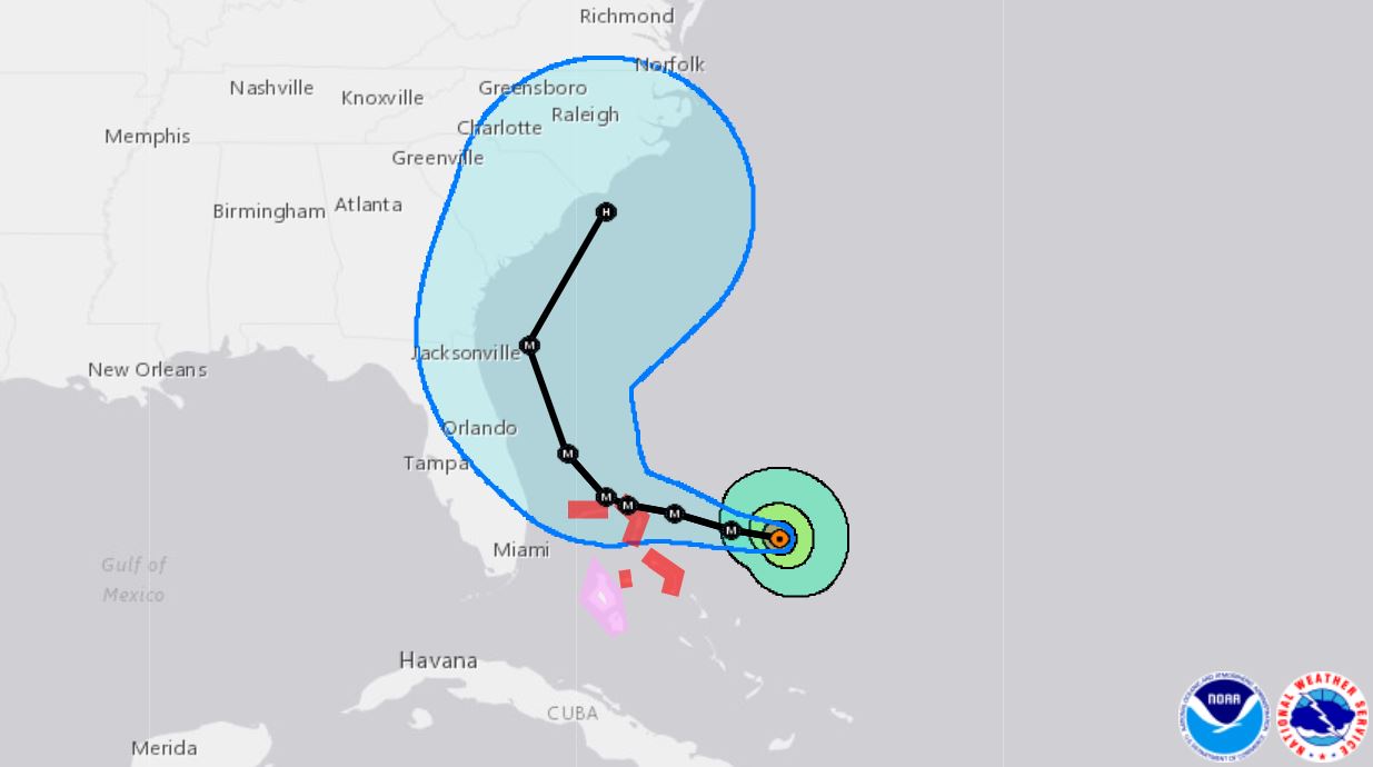
11 a.m. Wednesday: Still a Category 2 hurricane, Dorian continues to move up Florida’s eastern coast at about 9 miles per hour. The National Hurricane Center reports the storm remains about 90 miles from Daytona Beach, but now to the northeast. The storm shows the storm is not much further from Jacksonville, and it continues to move toward that major city.
Forecasters still expect the storm to climb the coast and turn north this evening. The storm shouldn’t make landfall but will continue to deliver tropical storm force winds to the mainland.
Hurricane force winds extend 70 miles from the eye of the storm, but still not far enough to strike land. Tropical storm force winds, though, extend 175 miles, far enough that buoys off the Georgia coast are already reporting sustained 40-mile-per-hour winds.
“A slow weakening is expected during the next few days,” a public advisory reads. “However, Dorian is expected to remain a powerful hurricane during this time.”
Meanwhile, parts of northeast Florida coast can expect 4 to 6 inches of rain today from the storm today, and most of northeast Florida should expect 2 to 4 inches.

Storm surge warnings have been dropped everywhere south of Cape Canaveral. Hurricane warnings have been downgraded to tropical storm warnings from Ponte Vedra Beach to the Volusia-Brevard county line, and storm warnings have been dropped further south.
![[Image of WPC QPF U.S. rainfall potential]](https://www.nhc.noaa.gov/storm_graphics/AT05/refresh/AL0519WPCQPF+gif/092607WPCQPF_sm.gif)
***
9 a.m. Wednesday: The eye of Hurricane Dorian now sits around 215 miles East-Southeast of Jacksonville as the storm churns north-northwest at 8 miles per hour. As the movement of the Category 2 storm slightly increased overnight, maximum sustained winds decreased but remained around 105 miles per hour.
Local impacts in Northeast Florida have been mild thus far: beach erosion in St. Johns County is the main worry, with large waves guaranteeing more of the same throughout what will be a soggy, windy day. Inland areas are dealing with squally rain, and those farther north will see the worst of it as the day progresses.
While the situation remains delicate, forecasters’ maps show it’s all but guaranteed the storm never makes landfall in Florida. In fact, five-day forecasts predict the storm will ride the entire eastern seaboard of the U.S. without striking land, remaining at hurricane strength the whole time.

Often compared to Hurricane Matthew from 2016, the storm indeed seems on a similar buzz saw pattern of riding the coastline and delivering tropical-storm-force winds or greater over a significant distance. The expansive storm continues to deliver hurricane-force winds 60 miles from its center and tropical-storm-level winds 175 miles out.
The 8 a.m. update noted that St. Augustine Beach saw a 46 mph wind with a 59 mph gust.
The cone of uncertainty at this point no longer includes any part of the Florida or Georgia coast, but the storm could still make landfall in South Carolina or any other coastal state further north.
Tropical storm warnings have been lifted south of Sebastian inlet, and hurricane warnings south of the Volusia-Brevard county line have been downgraded to tropical storm warnings. A hurricane warning is still in place from Ponte Vedra south, however.

***
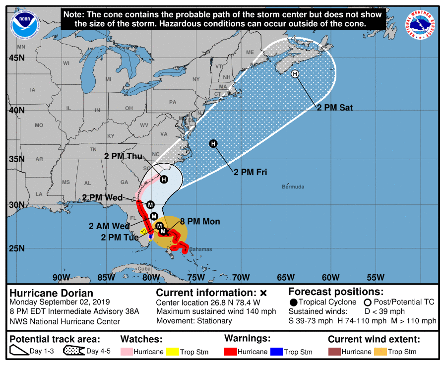
9 p.m. Tuesday: Hurricane Dorian has continued on a north-northwest trajectory at about 6 miles per hour, and forecasters predict it will turn further north on Wednesday. It still is not expected to make landfall in Florida.
The Category 2 storm’s size and speed have changed little since it took a northward turn from Grand Bahama Island. It’s simply moved further north and sits now around 105 miles east of Melbourne.
Indian River now reports winds of 40 miles per hour with gusts of 51 miles per hour occasionally. While the potential still exists for a westward jaunt, the hurricane most likely won’t make landfall before moving north to South Carolina. Hurricane-force winds are expected 60 miles from the center of the storm, and tropical storm winds extend 175 miles out.
***
5:03 p.m. Tuesday: Hurricane Dorian is moving north-northwest at about 6 miles hour, and seems to have officially passed by South Florida without wreaking havoc. While the storm system has started to speed up, its forecast path continues to bend away from Florida as the storm runs alongside the state.
Maximum sustained winds for the storm are near 110 miles per hour, which leaves the storm as a Category 2 Hurricane. “Dorian is expected to remain a powerful hurricane during the next couple of days,” reads an advisory from the National Hurricane Center. But it’s not the Category 5 monster it was when it first struck the Bahamas.
While the wind speeds have slowed, the size of the storm continues to expand. Tropical-storm-force winds can be detected 175 miles from Dorian’s center. Hurricane-force winds reach out 60 miles. AS for relation to Florida, the storm at 5 p.m. was about 105 miles due east of Vero Beach and 125 miles from Cape Canaveral.
Storm surge warnings have been extended north to Surf City, North Carolina.
Meanwhile, the hurricane warning area in Florida now runs from Sebastian Inlet to Ponte Vedra Beach. A hurricane watch extends from Ponte Vedra north to the Savannah River. Tropical storm warnings south of Jupiter inlet have been discontinued.
Meanwhile, the National Hurricane Center reports a system in the eastern Atlantic has evolved into a tropical depression. The current forecasts show that storm is heading far north of Florida and out to sea.

***
4:58 p.m. Tuesday: Several Florida counties are calling off their mandatory evacuations as Dorian travels closer to the state’s coast.
St. Lucie County will lift mandatory evacuations at 6 p.m. today.
The Emergency Operations Center is scaling back operations, and some personnel is being sent home. There have been no major power outages reported in the county and the only damage reported at this point is erosion, but assessments continue.
Martin County officials have lifted the mandatory evacuation order that was put into place beginning at 1 p.m. Sunday.
While shelters remain open, residents are now allowed to return to their home, county officials said in a press release.
Palm Beach County will lift the mandatory evacuation orders for Zones A and B at 4 p.m. today.
***
4:30 p.m. Tuesday: The National Hurricane Center reports Hurricane Dorian appears to be keeping a consistent distance from Florida’s coast— for now.
“The hurricane is moving nearly parallel to, but offshore of, the east coast of Florida,” reads a short public advisory.
Of course, officials remind “dangerous winds and life-threatening storm surge” accompany the Category 2 hurricane.
And Florida communities are reporting impacts from the storm already. Melbourne Beach now has reported sustained winds of 42 miles per hour with gusts as high as 60 miles per hour.
***
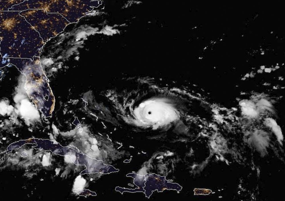
3:25 p.m. Tuesday: Images coming in from the Bahamas following Hurricane Dorian’s departure show tremendous wind and water damage.
CNN is incorporating satellite technology to show the impact of the storm. An Iceye slider shows how Grand Bahama Island looked before the storm and allows the most recent overhead images to be superimposed. While impacts like the absence of power mean only so much can be gleaned from images taken in outer space, the impact can be seen vividly.
These satellite images show Grand Bahama before and after Hurricane Dorian's wrath https://t.co/wI8yQiHGkz pic.twitter.com/3budNTJ1nB
— CNN (@CNN) September 3, 2019
Meanwhile, Orlando videographers Dave and Michael Meldeau, who were raised in the Bahamas, have taken footage from the air of the island. The video was shared with Twitter account @flstorms.
https://twitter.com/flstorms/status/1168936550874460163
The Nassau Guardian, meanwhile, has published footage from Abaco, where Dorian made landfall as a Category 5 storm. Pictures show homes torn apart by wind damage.

The Bahamas appear to have taken and absorbed the brunt of the storm. Dorian parked on Grand Bahama Island for 14 hours, in that time winding down to a strong Category 2 storm before heading northwest toward Florida.
***
2 p.m. Tuesday: Hurricane Dorian has picked up a little speed as it heads northwest from Grand Bahama Island toward Florida. Forecasters predict the storm path to were further north between now and Wednesday evening before turning north-northeast Thursday morning.
The storm also seems to be sustaining maximum winds of 110 miles per hour, with some higher gusts recorded, and it is not longer being listed as a major hurricane. That makes the storm a very strong Category 2 as it crawls across warm waters toward Florida.
The storm remains huge, with tropical storm winds extending as far as 175 miles from the eye. Hurricane-force winds extend 60 miles out from the storm’s center.
Due to changes in the storm path, a tropical storm watch has been lifted around Lake Okeechobee. The northwest Bahamas remain under tropical storm warnings even as the hurricane leaves the nation’s waters.
Most of Florida’s Atlantic coast remains under a hurricane warning.
***
1:40 p.m., Tuesday: Gov. Ron DeSantis at a press conference said Florida is remaining vigilant, even as the storm path for Hurricane Dorian turns away from Florida. He is advising individuals to heed local evacuation orders, and said local officials are making calls based on local conditions.
“This is a better track than 7 hours ago, but the important this is to stay safe, remain vigilant,” he said.
Read more from the presser here.
***
1 p.m. Tuesday: The National Hurricane Center reports the eyewall of Hurricane Dorian has cleared Grand Bahama Island, but residents still face “dangerous winds and life-threatening storm surge” that will continue through this evening.
Meanwhile, Treasure Coast locations have reported tropical-storm-force winds. Sebastian Inlet reports gusts of 49 miles per hour.
***
12:40 p.m. Tuesday: Weather experts say the 14-hour stationary position on Grand Bahama Island was indeed historic. According to National Oceanic and Atmospheric Administration records, no storm on record has ever stayed parked over land that long.
“The only comparable Category 5 beating is the one administered to Honduras by Hurricane Mitch of 1998, which spent 12 hours within 50 miles of the island of Guanaja as a Category 5 storm,” notes Bob Henson at Weather Underground.
But Mitch hung out on the water, its south side pounding an island but the most active parts of the storm remaining at sea.
The result has already been catastrophic for the Bahamas. Prime Minister Hubert Minnis has confirmed five already dead in Abaco, where Dorian made landfall as a Category 5 storm. Minister of National Security Marvin Dames confirmed to The Nassau Guardian that included a few children.
And once the storm ultimately leaves the nation to clean up the aftermath, Dames said he anticipates the death toll will rise.
“I caution Bahamians everywhere that that chances that we find more persons dead, those chances are real,” he said at a press conference.
***
Noon Tuesday: The most recent data shows Hurricane Dorian continues on a northwest trajectory from Grand Bahama Island at about 2 miles per hour. The National Hurricane Center has stopped listing the storm as a major hurricane, but it’s maximum sustained winds right now are being recorded at 110 miles per hour.
Whether the storm strengthens or continues to slow in speed will determine if it gets downgraded to a Category 2 in the next couple of hours. But the storm has gone from a Category 5 when it hit the Bahama’s to a slow 3 or fast 2 as it leaves.
***
11:45 a.m. Tuesday: Agriculture Commissioner Nikki Fried has now ordered the closure of 17 state forests and 60 campgrounds. The most recent closures include the Carl Duval Moore, Etoniah Creek, Welaka, and Seminole state forests.
Meanwhile, the office stresses that Floridians now must remain as alert as ever about the impending storm.
“Hurricane Dorian remains an extremely dangerous threat to much of our east coast as it moves slowly northward, with more than one million people under evacuation orders,” Fried said. “The next 12 hours will be critical – now is not the time for ‘hurricane fatigue.’
“Floridians need to pay close attention, heed all orders and warnings from emergency personnel, and ensure their plans are finalized. Our personnel and equipment are in place to assist in the storm’s aftermath, and our 1-800-HELP-FLA hotline is available to all consumers.”
Her office is providing infant and toddler hurricane kits for families with children ages five and younger. A Tampa staging area has 1.2 million gallons of water, 1.7 million meals, and 730,000 pounds of ice. Ready to go.
***
11 a.m. Tuesday: Hurricane Dorian is finally on the move, but it’s also growing.
The National Hurricane Center reports the storm has started moving at about 2 miles per hour in a northwestern direction. The cone of uncertainty for the storm no longer includes any part of the state of Florida. A hurricane watch from Deerfield Beach to Jupiter Inlet has been discontinues, and storm surge warnings have been discontinued south of Jupiter Inlet.
But that doesn’t mean danger has gone; a slight turn west could bring life-threatening winds to the Sunshine State.
For the moment, forecasters expect the storm to pick up speed over Tuesday and Wednesday after seeing the storm park north of Grand Bahama Island for more than half a day.
“On this track, the core of extremely dangerous Hurricane Dorian will gradually move north of Grand Bahama Island through this evening. The hurricane will then move dangerously close to the Florida east coast late today through Wednesday evening,” a public advisory says.
The storm will then move near the Georgia and South Carolina coasts Wednesday night and Thursday and near the North Carolina coast late Thursday.
Maximum storm winds have dropped to 110 miles per hour, but the storm’s size has increased substantially. The hurricane center said hurricane-force winds extend 60 miles from the storm’s center, and tropical storm winds extend 175 miles.

***
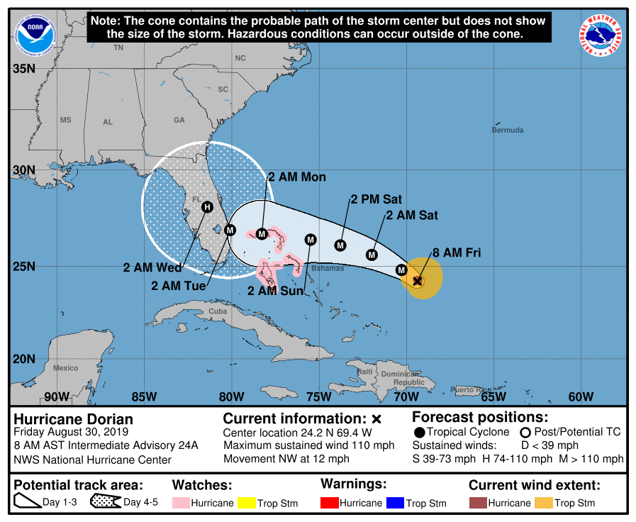
10 a.m. Tuesday: Hurricane Dorian has traveled the second-shortest distance in 24 hours by a major hurricane (Category 3 or stronger) since modern records began in 1850, according to Colorado State hurricane researcher Philip Klotzbach. The shortest on record is Hurricane Betsy in 1965, which traveled only 12 miles over the Atlantic.
Dorian spent most of the last couple days pounding the Bahamas as it moved at a speed of 1 mph or slower across the Atlantic. The stats show that from midnight Monday through Tuesday morning, the storm crawled just 30 miles in 30 hours.
The 185 mph maximum sustained winds from Dorian makes it the second-strongest storm, by wind speed, since 1950 in the Atlantic basin.
It is the strongest hurricane ever to make landfall in the Bahamas.
***
6:46 a.m. Tuesday: Hurricane Dorian has caused more than 1,300 flights to be canceled within, as well as into and out of, the U.S.
The flight-tracking site FlightAware says the unusually high amount of cancellations on Monday were due mostly to the ferocious storm. At least another 1,000 cancellations are expected Tuesday, with at least half due to the closure of the Orlando International Airport, scheduled for 2 a.m. The site says a total of 50 to 100 flights canceled a day would be typical.
***
5:45 a.m. Tuesday: Hurricane Dorian has dropped to Category 3 status, but National Hurricane Center officials remind that the storm remains dangerous and life-threatening. The storm boasts maximum wind strengths of 120 miles per hour and is expected to remain powerful for the next couple days, which are also the days when the hurricane poses the most significant direct threat to Florida.
The storm remains in a stationary position north of Grand Bahama Island, continuing to pound the island nation. But the National Hurricane Center expects this morning the storm will move north-northwest toward Florida. By Wednesday evening, the storm should turn north before peeling north-northeast Thursday.
“On this track, the core of extremely dangerous Hurricane Dorian will continue to pound Grand Bahama Island today,” reads a public advisory. “The hurricane will then move dangerously close to the Florida east coast late today through Wednesday evening, very near the Georgia and South Carolina coasts Wednesday night and Thursday, and near or over the North Carolina coast late Thursday.”
Juno Beach Pier has reported gusts as high as 61 miles per hour.
A Tropical Storm Warning has been issued from Ponte Vedra Beach north to Altamaha Sound in Georgia.
The most recent forecast shows Florida just outside the ominous “cone of uncertainty, but the storm is still expected to deliver strong winds to the state, and forecasters remind a slight shift west puts the storm on the Atlantic coast.
***
11 p.m. Monday: Florida remains alert and in wait as Hurricane Dorian cycles, still stationary, just north of Grand Bahama Island. The National Hurricane Center continues to predict a slow, northwestern motion in the storm early Tuesday. Meanwhile, Florida communities are starting to report wind connected to the storm.
“On this track, the core of extremely dangerous Hurricane Dorian will continue to pound Grand Bahama Island into Tuesday morning,” reads the most recent warning from the Center.
“The hurricane will then move dangerously close to the Florida east coast late Tuesday through Wednesday evening, very near the Georgia and South Carolina coasts Wednesday night and Thursday, and near or over the North Carolina coast late Thursday and Friday.”
Juno Beach Pier in northern Palm Beach County has reported sustained winds of 44 miles per hour and gusts of up to 56 miles to hour.
The storm remains a Category 4, but wind speeds have slowed to about 130 miles per hour. Forecasters remind the storm will still be classified as a major hurricane as it rides Florida’s eastern coast.
And the storm remains large. Hurricane-force winds extend 45 miles out from the storm’s center, and tropical-storm-force winds reach 150 miles out.
Residents along Florida’s Atlantic Coast can expect four to eight inches of rain, and up to 10 inches in isolated areas, connected to the storm.
***
8 p.m. Monday: Hurricane Dorian continues to stall over the northern Bahamas, losing little of its strength and continuing to pummel the archipelago with 140 miles per hour winds and pounding rain.
As of the latest forecast, it was about 25 miles northeast of Freeport, Grand Bahama and about 105 miles off West Palm Beach. It had just started to make a slight west-northwesterly turn.
Maximum sustained winds were at 150 mph with higher gusts.
The core of extremely dangerous Hurricane Dorian will continue to pound Grand Bahama Island through much of today and tonight.
The hurricane will move dangerously close to Florida’s east coast tonight through Wednesday night.
***
6 p.m. Monday: Walt Disney World will close early because of Hurricane Dorian.
Disney World officials said Monday that its four theme parks would close by 3 p.m. on Tuesday.
The theme park resort also plans to close its water park, miniature golf courses and its restaurants and shops at Disney Springs by 3 p.m. on Tuesday.
Disney World officials say its resorts will remain open.
Its campground will close at 3 p.m. Tuesday and stay closed until the hurricane passes near the Florida coast. Guests at the campground will be relocated to other resorts at Disney World.
***
5:25 p.m. Monday: Bahamas Prime Minister Hubert Minnis says at least five people have died in the Abaco Islands as Hurricane Dorian continues to pound the region as a Category 4 storm.
Minnis said Monday that there are also people in nearby Great Bahama island who are in serious distress. He said rescue crews would respond to calls for help as soon as weather conditions allow.
He said many homes and buildings had been severely damaged or destroyed.
***
11 a.m. Monday: Hurricane Dorian, while continuing to batter the Bahamas on Monday with life-threatening winds and storm surge, has weakened very slightly to a Category 4 storm.
The National Hurricane Center in Miami said in an advisory at 11 a.m. EDT that Dorian’s maximum sustained winds are 155 mph (250 kph), which takes the extremely dangerous storm down one notch, from Category 5.
The storm was expected to continue inflicting devastation on Grand Bahama Island throughout Monday.
The center said the storm would move “dangerously close” to the Florida East Coast late Monday through Wednesday evening.
A hurricane warning along Florida’s east coast has been extended northward to the Flagler-Volusia county line. A hurricane watch has been extended northward to Altamaha Sound in Georgia.
The storm’s center was located about 30 miles (50 kilometers) northeast of Freeport, Grand Bahama Island and about 110 miles (180 miles) east of West Palm Beach.
***
8 a.m. Monday: Hurricane Dorian continued its crawl over Grand Bahama Island, tracked at moving 1 mph and perhaps auguring the long-awaited turn to the north that would spare Florida the worst.
Still, a robust Category 5 with 165 mph winds, the storm’s effects are being felt far away from the eye. Hurricane-force winds stretch 45 miles from the center, with tropical-storm-force winds, 140 miles from the center.
As the storm weakens, tropical-storm-force winds will likely expand from the center.
A hurricane warning is still in effect from the Volusia/Brevard county line to Jupiter Inlet; the hurricane watch, meanwhile, extends to the mouth of the St. Mary’s River.
The question for Florida: will this be a repeat of Hurricane Matthew three years ago? Or will it be worse?
A lot depends on the turn northward. Does it happen on Monday morning? Or will further delay confound forecasters and the public alike?
***
5 a.m. Monday: Hurricane Dorian essentially stalled over Grand Bahama Island, moving along at just 1-2 mph and pounding Freeport.
Dorian is slightly weakened but still a powerful Category 5. It is still projected to skirt the Florida coast Tuesday and Wednesday as a major hurricane.
In the 5 a.m. update Monday, the storm has maximum winds of 165 mph. and the National Hurricane Center forecasts it still will be “will remain a dangerous major hurricane for the next several days.”
Forecasters are interpreting the forward-motion stall as the beginning of the hurricane’s change of direction into a northern track.
The forecast projects the track to take the storm to about 40 miles off the coast of Stuart around 2 p.m. Tuesday, with maximum sustained winds continuing at 165 mph. At 2 a.m. Wednesday it should be 20-30 miles off the coast of Cape Canaveral, with sustained winds of 155 mph.
“The official track forecast is very close to the previous one and the corrected dynamical model consensus, HCCA. Although the official forecast does not show Dorian making landfall along the Florida east coast, it is still possible for the hurricane to deviate from this forecast, and move very near or over the coast,” the latest NHC advisory states.
***
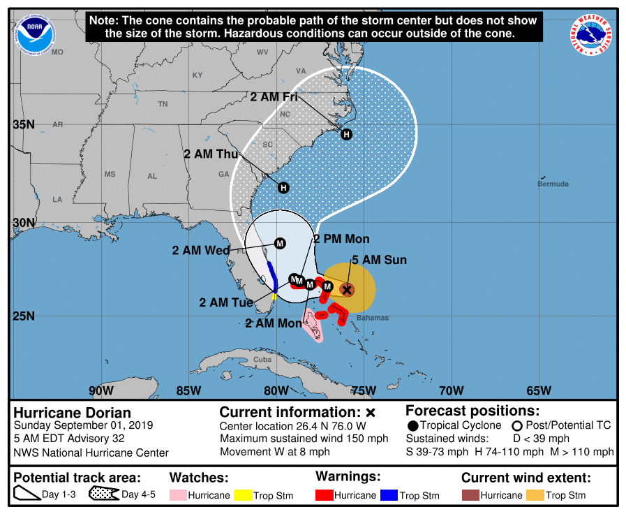
11 p.m. Sunday: Hurricane Dorian made landfall on the eastern end of Grand Bahama Island as a “Catastrophic” Category 5 storm, according to the National Hurricane Center. While all models show the storm should turn north after winds begin to hit Florida, the hurricane continues moving west at 6 miles per hour.
The storm has maximum wind speeds of an estimated 180 miles per hour. It is moving toward Florida at a slower rate than previously expected, and winds will hit land sometime between 2 a.m. and 8 a.m. A Hurricane Watch has been extended all the way north on Florida’s east coast to the Georgia border, and the storm is expected to remain a major hurricane as it passes north by Georgia.
“Life-threatening storm surges and dangerous hurricane-force winds are expected along portions of the Florida east coast through midweek, and storm surge and hurricane warnings are in effect,” the Center warns. “Only a slight deviation to the left of the official forecast would bring the core of Dorian near or over the Florida east coast. Residents should listen to advice given by local emergency officials.”

***
A list of open shelters can be found here.
***
8 p.m. Sunday: Now a Category 5 Hurricane, Dorian is being described as “catastrophic” by the National Hurricane Center as it pounds Great Abaco and the Grand Bahama Islands. The slow-moving storm is still moving west at about 5 miles per hour.
Forecasters predict the first hurricane-force winds will hit Florida around 2 a.m. Monday morning.

***
5 p.m. Sunday: A hurricane warning was issued from Jupiter Inlet in Palm Beach County to the Volusia/Brevard county line. A hurricane watch was issued from the Volusia/Brevard county line to the Flagler/Volusia county line. A tropical storm warning was in effect north of Deerfield Beach to Jupiter Inlet, and a tropical storm watch was in effect from north of Golden Beach to Deerfield Beach and for Lake Okeechobee.
***
2:15 p.m. Sunday: The National Hurricane Center in Miami says Dorian made a second landfall at 2 p.m. on Great Abaco Island near Marsh Harbour at 185 mph (285 kph).
The center says that is tied for the strongest Atlantic hurricane landfall on record with the 1935 Labor Day hurricane.
The Hurricane Center said Dorian’s maximum sustained winds stood at a monstrous 185 mph (295 kph), with higher gusts. Dorian is moving west at 7 mph (11 kph).
The storm’s center is about 185 miles (295 kilometers) east of West Palm Beach, Florida. A Hurricane Watch is in effect for Florida from the north of Deerfield Beach to the Volusia-Brevard county line. Hurricane conditions are possible within the watch area by late Monday or early Tuesday.
***
11:30 a.m. Sunday: Officials at Florida’s busiest airport say they are rescinding plans to close on Monday.
Orlando International Airport officials said late Saturday that the airport would remain open Monday because of the turn northward in Hurricane Dorian’s projected path.
The airport initially had planned to stop commercial flights at 2 a. m. Monday — for passenger safety and to give the airport’s 25,000 workers enough time to secure their homes and be with their families.
The airport had 47.7 million passengers travel through it last year.
***
11 a.m. Sunday: The National Hurricane Center has issued a hurricane watch for the East Coast of Florida from north of Deerfield Beach to the Volusia/Brevard County line. A storm surge watch also is in effect for that area.
Hurricane Dorian’s winds have increased to 180 mph, making it an extremely dangerous Category 5 storm. It is pounding parts of the Bahamas. The storm is the strongest hurricane in modern records to hit the northwestern Bahamas, the National Hurricane Center said.
The continued threat to Florida has led to mandatory evacuations being ordered in Palm Beach, Martin and Brevard counties.
At 11 a.m. Dorian was about 205 miles east of West Palm Beach. It was moving west at 7 mph.
***
9:45 a.m. Sunday: Potentially devastating winds from Hurricane Dorian have strengthened yet again as the storm nears the Bahamas.
The National Hurricane Center in Miami said Sunday that maximum sustained winds have increased to 175 mph (280 kph) from 160 mph (260 kph) as it approaches Great Abaco Island. It is moving west at 8 mph (13 kph).
The center said at 9:30 a.m. EDT that the Category 5 storm is 25 miles (40 kilometers) east-northeast of Great Abaco Island and about 210 miles (340 kilometers) east of West Palm Beach, Florida.
The Hurricane Center is warning of potentially devastating wind gusts of more than 200 mph (321 kph) and destructive waves of up to 20 feet (6 meters).
“These hazards will cause extreme destruction in the affected areas,” the center said, “and will continue for several hours.”
***
8:55 a.m. Sunday: Weather forecasters say predictions that powerful Hurricane Dorian will slow to a crawl over the Bahamas complicates their outlook for the United States.
The National Hurricane Center says Dorian could nearly stall over Great Abaco Island or Grand Bahama Island for more than 24 hours starting late Sunday.
Hurricane Center Director Ken Graham says that would be catastrophic for the island chain. Dorian was upgraded to the most powerful designation of Category 5, with maximum sustained winds increasing to 160 mph (260 kph). Forecasters say ocean levels could rise up to 20 feet (6 meters) in parts of the northern Bahamas with the storm surge topped with huge waves.
Graham says the storm stalling also complicates the U.S. forecast. The time allows small changes in the winds that steer the storm, which means Dorian can still make landfall anywhere from Florida to North Carolina during the next five days.
***
5 a.m. Sunday: As Hurricane Dorian moves closer to the northern Bahamas, rainfall estimates have gone up for the Caribbean archipelago and the coastal Carolinas.
At around 5 a.m. Sunday, the center of the Category 4 storm was approximately 70 miles (110 kilometers) east of Great Abaco Island in the Bahamas and 255 miles (410 kilometers) east of West Palm Beach, Florida. The hurricane is still moving west at 8 mph (13 kph), with maximum sustained winds of 150 mph (240 kph).
A tropical storm warning was issued between Deerfield Beach up to Sebastian Inlet on southern Florida’s east coast, while a tropical storm watch was issued between Deerfield Beach down to Golden Beach.
***
11 p.m. Saturday: Forecasters say Hurricane Dorian, hours after becoming an “extremely dangerous” Category 4 storm, has become even stronger.
The U.S. National Hurricane Center says Dorian is now packing top sustained winds of 140 mph (220 kph) as it approaches the northwestern Bahamas. The storm hours earlier had winds of about 130 mph (215 kph).
At 11 p.m. EDT Friday, Dorian was centered about 375 miles (605 kilometers) east of the northwestern Bahamas. That was about 545 miles (880 kilometers) east of West Palm Beach, Florida.
The storm is moving to the west-northwest at 10 mph (17 kph). The Miami-based center says Dorian should be near or over the northwestern Bahamas on Sunday and be near Florida’s east coast by late Monday.
***
5 p.m. Saturday: The National Hurricane Center has issued a tropical storm watch from Deerfield Beach in Broward County to Sebastian Inlet in Brevard County. A tropical storm watch means that tropical storm conditions are possible within the watch area, generally within 48 hours.
The latest forecast path keeps Hurricane Dorian off the East Coast of Florida. However, the NHC warns that Dorian is forecast to slow down and turn northward as it approaches the coast, so “life-threatening storm surge and dangerous hurricane-force winds are still possible along portions of the Florida East Coast by the early to middle part of next week.”
The new forecast path brings a risk of strong winds and dangerous storm surge increasing risk along the coasts of Georgia, South Carolina and North Carolina during the middle of next week.
The intense Category 4 hurricane is expected to slam into the northwestern Bahamas on Sunday. At 5 p.m. Saturday, the storm was about 355 miles east of West Palm Beach. It had sustained winds of 150 mph.
***
12:47 p.m. Saturday: Gov. Ron DeSantis is warning Floridians not to let their guard down despite shifts in forecasts showing Hurricane Dorian possibly staying off the shore of the state. The cone of potential pathways still includes much of the state, and DeSantis says if residents are within that cone they should be prepared.
“Looking at these forecasts, a bump in one direction or the other could have really significant ramifications in terms of impact. If it bumps further east, that obviously is positive. If it bumps just a little west, then you’re looking at really, really significant impacts. Don’t make any assumptions, remain vigilant and be prepared,” DeSantis said at a briefing Saturday morning.
***
11 a.m. Saturday: The Gulf Coast of Florida and part of South Florida are now out of the cone of probability for Hurricane Dorian. The latest path from the National Hurricane Center keeps the eye of the monster storm off the East Coast of Florida.
“You can look at a little bit of a movement to the west and all of a sudden we’re looking at a much different scenario,’’ DeSantis said at a briefing at the state Emergency Operations Center.
“Even if doesn’t directly strike Florida, this is a big powerful storm and you’re still looking at really significant storm surge on the east coast of Florida,’’ he said.
Dorian’s winds have increased to 150 mph, and the storm continues to move to the west at about 8 mph.
***
8 a.m. Saturday: Hurricane Dorian is strengthening as it moves west toward the Bahamas and Florida.
The National Hurricane Center in Miami says maximum sustained winds increased Saturday morning to 145 mph (230 kph), up from 140 mph (220 kph).
As of about 8 a.m. Saturday, the Category 4 storm was 280 miles (450 kilometers) east of the northwestern Bahamas and 445 miles (715 kilometers) east of West Palm Beach, Florida. The storm was traveling west at 12 mph (19 kph).
The hurricane center says the core of Dorian is expected to be near or over the northwestern Bahamas on Sunday and near the Florida east coast late Monday. Strong winds and life-threatening storm surge are also possible along the shores of Georgia and South Carolina by the middle of next week.
***
11 p.m. Friday: The latest computer models have Hurricane Dorian shifting more northeastward and keeping the storm just offshore of Florida’s East Coast. The storm has also gotten stronger and now has winds of 140 mph.
However, as hurricane veterans in Florida know, these paths can change repeatedly and right up to the moment of landfall.
The National Hurricane Center warned, “Although the official forecast track has been nudged northeastward to near the east coast of Florida the risk of significant impacts over much of the Florida peninsula remains high.”
The state can still expect a prolonged period of storm surge, high winds and rainfall. Parts of inland Florida could also see hurricane-force winds, the NHC said.

***
10 p.m. Friday: Brevard County has ordered mandatory evacuations to begin at 8 a.m. Sunday in anticipation of Hurricane Dorian’s arrival.
According to a news release, the residents who should leave are those who live on the barrier islands, including areas from Kennedy Space Center south to the south beaches, and Merritt Island; those in mobile homes or manufactured housing, those in low-lying, flood-prone areas, those with special medical needs such as electrical dependence.
Palm Beach County has also said its hurricane shelters will open Sunday morning, but officials haven’t ordered evacuations.
Officials are urging residents to avoid shelters if possible and try to stay with family or friends or local hotels outside of evacuation zones. During a visit to the Palm Beach County Emergency Operations Center on Friday, DeSantis said those people evacuating should not try to drive for hours on Interstate 95.
“We know this storm is coming in a westerly direction. We know it’ll eventually turn north,” DeSantis said, according to the Palm Beach Post. “We don’t really know where it’s going to turn precisely. You could end up even driving into the storm if you take that route.”
***
8:30 p.m. Friday: The National Hurricane Center says Dorian has strengthened to an extremely dangerous Category 4 hurricane with maximum sustained winds near 130 mph. NOAA Hurricane Hunters confirmed the strengthening in a recent flight.
***
8 p.m. Friday: Hurricane Dorian’s winds have increased to 125 mph as it continues to move to the west-northwest at 10 mph, the National Hurricane Center says.
Hurricane-force winds extend outward up to 30 miles from the center and tropical-storm-force winds extend outward up to 115 miles.
The latest projected path has Dorian reaching Florida’s East Coast on Tuesday and then slowly moving up the eastern side of the state.
***
5 p.m. Friday: Hurricane Dorian has strengthened into a Category 3 storm with winds of 115 mph as it bears down on the northwestern Bahamas. It’s expected to be Category 4 when it reaches the East Coast.
The storm is expected to begin affecting Florida this weekend, and the state could see tropical-storm-force winds 24 to 36 hours before Dorian makes landfall.
A hurricane warning has been issued for the northwestern Bahamas, including the Abacos, Berry Islands, Bimini, Eleuthera, Grand Bahama Island, and New Providence.
On its current track, Dorian is expected to be over the northwestern Bahamas on Sunday and be near Florida’s East Coast late Monday, the National Hurricane Center said.
***
11 a.m. Friday: The National Hurricane Center says Hurricane Dorian is expected to become an extremely dangerous major hurricane soon with additional strengthening likely as it heads for the northwestern Bahamas and the Florida peninsula.
The latest advisory also says the hurricane’s forward motion is expected to slow, which means Dorian would more like making landfall early Tuesday morning. However, before it reaches land, Florida will be dealing with prolonged wind, storm surge, and rainfall, according to the hurricane center.
Florida can expect 6 to 12 inches of rain, with up to 18 inches in some cases, NHC said.
Read the latest advisory here.
***
8 a.m. Friday: Hurricane Dorian is a Category 2 hurricane early Friday morning and is expected to strengthen into a major hurricane.
It could become a Category 3 hurricane today.
“This system is very close to being a Cat 3 hurricane,” Lixion Avila, senior hurricane specialist said Friday morning.
The storm was about 230 miles northeast of the southeastern Bahamas Friday at 8 a.m. Current projections have it passing those islands before turning west and striking the northwest Bahamas as a major hurricane late in the weekend. A hurricane watch is in effect for the northwest Bahamas.
A strong high pressure will build to the north of Dorian, which will then make it move west toward Florida but it’s too soon to pinpoint a landfall location on Florida’s east coast.
Model guidance then shows Dorian making a turn to the north early next week but are not in agreement on where that will happen with scenarios ranging from Florida’s east coast to the west coast or somewhere in between.
“It’s slowed down considerably,” National Weather Service forecaster John McMichael said. “At this point, they’re expecting it to be a Category 4 when it reaches the east coast of Florida.”
Read the full public advisory here.
***
5 p.m. Thursday: The National Hurricane Center says the risk of devastating hurricane-force winds along the Florida east coast and peninsula late this weekend and early next week from Hurricane Dorian continues to increase. The likelihood of life-threatening storm surge in the state is also increasing. The big questions now are where and when Dorian will make landfall.
The 5 p.m. advisory from the Hurricane Center has the storm coming ashore at Vero Beach, but forecasters caution that some computer models show landfall farther south.
***
3:30 p.m. Thursday: DeSantis expanded his declaration of a state of emergency to all 67 Florida counties. He had made the declaration for 26 counties in the forecast path of Hurricane Dorian on Wednesday.
“Due to Hurricane Dorian’s uncertain projected path, I am expanding the state of emergency to include all 67 counties throughout Florida,” the Governor said in a statement. “As it increases strength, this storm has the potential to severely damage homes, businesses and buildings, which is why all Floridians should remain vigilant. Do not wait until it is too late to make a plan.”
Earlier during a visit to the National Hurricane Center in Miami, DeSantis said, “All Floridians really need to monitor Hurricane Dorian and make the necessary preparations. This is a track that has a significant amount of uncertainty.”
“You could make the case that this could have an effect on every part of the state,” he said.

***
11 a.m. Thursday: The latest forecast for Hurricane Dorian has shown the storm is strengthening and possibly being a Category 4 storm when it approaches Florida. The 11 a.m. advisory says winds could reach 130 mph when the hurricane is just off the South Florida coast on Sunday morning.
“The risk of devastating hurricane-force winds along the Florida east coast and peninsula late this weekend and early next week continues to increase, although it is too soon to determine where the strongest winds will occur,” the National Hurricane Center says in a discussion of the storm.
***
8 a.m. Thursday: Hurricane Dorian has slowed just a bit, and now it looks as if it could make landfall on Labor Day just north of Vero Beach. Now a Category 1 storm, Dorian is expected to begin intensifying rapidly. It could be a Category 3 when it makes landfall.
The latest projection has that happening early Monday, and the storm is expected to remain at hurricane strength as it moves over Central Florida.
“This would be the strongest hurricane to hit Central Florida in over 30 years,” Fox 35 meteorologist Glenn Richards told the Orlando Sentinel. “Hurricane-force sustained winds would be carried across the entire width of the state if the current forecast holds.”
It’s still too early to focus on the precise forecast path, however. The storm is expected to make a left turn. Exactly when and how sharp that turn is will “be critical in determining the exact location and timing of Dorian’s strike on the east coast of Florida or elsewhere in the southeastern U.S.,” according to weather.com.
***
8 p.m. Wednesday: The latest projection from the National Hurricane Center for Hurricane Dorian has it making landfall just south of Melbourne overnight Sunday. By 2 p.m. Monday, Labor Day, the hurricane could be sitting over Kissimmee with winds up to 100 mph. Tropical force winds (more than 45 mph) could extend over the entire peninsula beginning Saturday morning, so it’s important not to focus too much on the exact path.
Where and when Hurricane Dorian makes landfall in Florida is still an unknown. Wherever it is, it’s most likely to happen while the state is experiencing the second King Tide of the season. King Tides are exceptionally high tides that can cause flooding in low-lying areas even when there’s not a hurricane sitting off the coast.
Puerto Rico appears to have escaped the worst of Hurricane Dorian. No hurricane-force winds were measured on the island, and the eye was about 60 miles northeast of San Juan on Wednesday evening.
The U.S. Virgin Islands saw up to 5 inches of rain in some places and 80 mph winds. In St. Thomas, yachts were overturned or run aground, streets had some flood damage, and power was out for many, the St. Thomas Source reported.
***
5 p.m. Wednesday: DeSantis has declared a state of emergency in anticipation of Hurricane Dorian approaching Florida.
By declaring a state of emergency, the Governor “is ensuring that state and local governments have ample time, resources and flexibility to prepare,” according to a news release.
“Because of the uncertainty in the track of this storm, every resident along the East Coast needs to be ready,” Florida Division of Emergency Management Director Jared Moskowitz, said in the release.
“Every Florida resident should have seven days of supplies, including food, water and medicine, and should have a plan in case of disaster,” DeSantis said.
Dorian became a Category 1 hurricane on Wednesday as it headed for the U.S. Virgin Islands and Puerto Rico.
In the latest forecast, Dorian could reach Florida’s East Coast as a Category 3 hurricane overnight Sunday into Monday, which is Labor Day. The projected path shows it making landfall at Melbourne. However, the National Hurricane Center cautions that it is too early to focus on the specific path. All of the Florida peninsula is in the cone of probability.
Earlier updates are below:
Floridians, particularly those along the East Coast, are being told to prepare for a major hurricane that could hit the state during the Labor Day weekend.
The storm, which became Hurricane Dorian on Wednesday, is projected to reach the state Sunday or Monday as a major hurricane, with winds topping 110 mph.
“We’ve been monitoring this storm with (the State Emergency Response Team) and will continue to watch closely,” DeSantis tweeted. “All Floridians on the East Coast should have seven days of supplies, prepare their homes & follow the track closely.”
DeSantis also advised Floridians to brace for impacts of strong winds, torrential rains and flooding.
Dorian’s projected path shifted north of Hispaniola on Wednesday, putting the system away from the island’s mountains and into more open water. Earlier in the week, Dorian had been predicted to remain a tropical storm when it reached Florida.
“Once the cyclone reaches the Western Atlantic well east of the Bahamas, it will encounter a favorable environment of low shear and warm waters, resulting in a more marked intensification,” the National Hurricane Center posted late Wednesday morning. “The NHC forecast is more aggressive than the previous one and brings Dorian to Category 3 intensity by the end of the period.”
Tropical-storm force winds are expected to reach Florida on Saturday, with the storm expected to make landfall late Sunday or Monday morning. The “cone of probability,” which offers a general idea of where the storm could make landfall, stretched Wednesday from around Miami to Savannah, Ga., though it was centered on the East Coast of Central Florida.
Jacksonville Mayor Lenny Curry said Wednesday his city’s Emergency Operations Center is starting to ramp up and would begin full-time operations Thursday morning.
“We’ve done this before. We’ve been through this together. This is no time to panic,” Curry said during a news conference. “We don’t know what will develop in the days ahead, but it’s time to know your evacuation zone.”
Curry said no changes had been made in plans for the Florida State University-Boise State football game, which is scheduled for 7 p.m. Saturday at TIAA Bank Field in Jacksonville.
Dorian could be the fifth hurricane to impact the state in four years.
In 2016, Hurricane Matthew caused damage as it skirted the East Coast, and Hurricane Hermine knocked out electricity in the Tallahassee area. Hurricane Irma barreled through much of the state in 2017, and Hurricane Michael devastated parts of the Panhandle last year.
5 comments
TheRealJimDavis
August 29, 2019 at 7:58 am
Thank God, the Lord Jesus Christ, that DeSantis is Governor and Curry is Mayor of Duval County.
History has shown us that liberals and Democrats compound disasters when they lead preparation and recovery relief.
Thank you Jesus.
TheRealJimDavis
August 29, 2019 at 9:03 am
I continue to have confidence in the Mayor, the Governor, and now our President, Donald Trump
“Florida Gov. Ron DeSantis declared a state of emergency for 26 counties in Dorian’s possible path and said he spoke with President Donald Trump on Wednesday evening about storm preparations.”
https://www.usatoday.com/story/news/weather/2019/08/29/hurricane-dorian-hit-florida-major-category-3-storm-labor-day/2149021001/
gary
August 30, 2019 at 6:47 am
God Bless DJT and Gov.Ron DeSantis… they will make this be a bee sting for our state!
Jim
August 30, 2019 at 12:41 pm
Ah, yes, The Chosen One will fly down to part the waters before they flood Mar-a-Loco.
henryhoffman
September 4, 2019 at 9:50 am
Thank God we learned to respond in time! I don’t know how much it depends on the governor, but a fact is a fact!
Comments are closed.